New Plymouth geodata
New Plymouth (Taranaki) is a seat of a first-order administrative division; located in New Zealand in Pacific/Auckland (GMT+12) time zone. With population of 49,168 people, there are 18 cities with bigger population in this country. Compared to other cities in New Zealand, 55.6% of cities are located further ↓South; 57% of cities are located further →East and 68.6% of cities have lower elevation than New Plymouth. Note1


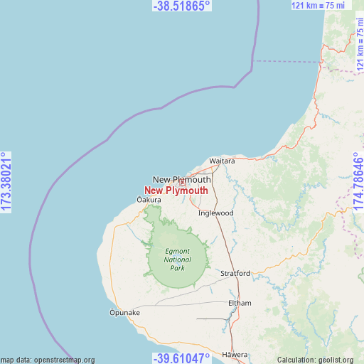
New Plymouth GPS coordinates[2]
39° 4' 0.012" South, 174° 4' 59.988" East
| Map corner | latitude | longitude |
|---|---|---|
| Upper-left | -38.51865°, | 173.38021° |
| Center: | -39.06667°, | 174.08333° |
| Lower-right: | -39.61047°, | 174.78646° |
| Map W x H: | 121.4×121.4 km | = 75.4×75.4mi |
| max Lat: | -34.99604° ⇑44.4% North |
| New Plymouth: | -39.06667° |
| min Lat: | ⇓55.6% South -46.6° |
| min Long | New Plymouth | max Long |
| -176.55973° | 174.08333° | 178.33333° |
| W 43%⇐ | ⇒57% E |
Elevation
Elevation of New Plymouth is 64 m = 210 ft, and this is 20.4 m = 67 ft below average elevation for this country.
| Max E: |
819 m = 2687 ft | 31.4% |
| Avg. | 84.4 m = 277 ft | |
| New Plymouth | 64 m = 210 ft | |
Min E: |
3 m = 10 ft | 68.6% |
See also: New Plymouth elevation on elevation.city.
Geographical zone
New Plymouth is located in South temperate zone (between Tropic of Capricorn and the Antarctic Circle). Distance of this Southern Tropic circle is 1737.9 km =1079.9 mi to North.| Distance of | km | miles | from New Plymouth |
|---|---|---|---|
| Equator | 4343.8 | 2699.1 | to North |
| Tropic Capricorn | 1737.9 | 1079.9 | to North |
| Antarctic Circle | 3057.4 | 1899.8 | to South |
| South Pole | 5663.3 | 3519 | to South |


Nearby cities:
15 places around New Plymouth: (largest is in red/bold)
• Eltham
44.4 km =27.6 mi,  155°
155°
• Hawera
60.9 km =37.8 mi, 163°
• Kawhia
128.2 km =79.7 mi,  29°
29°
• Manaia
53.9 km =33.5 mi,  175°
175°
• Okato
22.7 km =14.1 mi,  229°
229°
• Opunake
47.4 km =29.5 mi,  204°
204°
• Otorohanga
138 km =85.7 mi,  44°
44°
• Patea
84.2 km =52.3 mi, 155°
• Piopio
104.9 km =65.2 mi,  50°
50°
• Raglan
157.1 km =97.6 mi, 26°
• Turangi
149.2 km =92.7 mi,  86°
86°
• Waiouru
143.9 km =89.4 mi,  108°
108°
• Waitara
15.2 km =9.4 mi,  61°
61°
• Wanganui
127.1 km =79 mi,  139°
139°
• Waverley
91 km =56.5 mi,  148°
148°
In other languages:
- In Spanish: Nueva Plymouth
- In Italian: Distretto di New Plymouth
- In Russian: Нью-Плимут
- In Chinese: 新普利茅斯
Sources, notices
• [Note1] Compared only with cities in New Zealand existing in our database
• [Src1] Map data: © OpenStreetMap contributors (CC-BY-SA)
• [Src2] Other city data from geonames.org with taken over terms of usage.
• [Src3] Geographical zone / Annual Mean Temperature by Robert A. Rohde @ Wikipedia
