Waitara geodata
Waitara (Taranaki) is a populated place; located in New Zealand in Pacific/Auckland (GMT+13) time zone. With population of 6,318 people, there are 52 cities with bigger population in this country. Compared to other cities in New Zealand, 56.5% of cities are located further ↓South; 54.1% of cities are located further →East and 89.9% of cities have higher elevation than Waitara. Note1


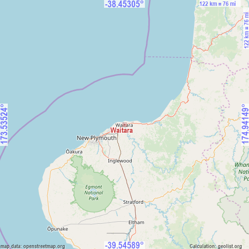
Waitara GPS coordinates[2]
39° 0' 5.688" South, 174° 14' 18.096" East
| Map corner | latitude | longitude |
|---|---|---|
| Upper-left | -38.45305°, | 173.53524° |
| Center: | -39.00158°, | 174.23836° |
| Lower-right: | -39.54589°, | 174.94149° |
| Map W x H: | 121.5×121.5 km | = 75.5×75.5mi |
| max Lat: | -34.99604° ⇑43.5% North |
| Waitara: | -39.00158° |
| min Lat: | ⇓56.5% South -46.6° |
| min Long | Waitara | max Long |
| -176.55973° | 174.23836° | 178.33333° |
| W 45.9%⇐ | ⇒54.1% E |
Elevation
Elevation of Waitara is 8 m = 26 ft, and this is 76.4 m = 251 ft below average elevation for this country.
| Max E: |
819 m = 2687 ft | 89.9% |
| Avg. | 84.4 m = 277 ft | |
| Waitara | 8 m = 26 ft | |
Min E: |
3 m = 10 ft | 10.1% |
See also: New Zealand elevation on elevation.city.
Geographical zone
Waitara is located in South temperate zone (between Tropic of Capricorn and the Antarctic Circle). Distance of this Southern Tropic circle is 1730.7 km =1075.4 mi to North.| Distance of | km | miles | from Waitara |
|---|---|---|---|
| Equator | 4336.6 | 2694.6 | to North |
| Tropic Capricorn | 1730.7 | 1075.4 | to North |
| Antarctic Circle | 3064.6 | 1904.3 | to South |
| South Pole | 5670.5 | 3523.5 | to South |


Nearby cities:
15 places around Waitara: (largest is in red/bold)
• Eltham
47.8 km =29.7 mi,  173°
173°
• Hawera
65.7 km =40.8 mi,  176°
176°
• Kawhia
115.5 km =71.8 mi,  25°
25°
• Manaia
61.6 km =38.3 mi,  188°
188°
• New Plymouth
15.2 km =9.4 mi,  241°
241°
• Okato
37.8 km =23.5 mi,  234°
234°
• Opunake
60.2 km =37.4 mi,  212°
212°
• Otorohanga
123.5 km =76.7 mi,  42°
42°
• Patea
86.7 km =53.9 mi, 165°
• Piopio
90 km =55.9 mi,  48°
48°
• Raglan
144.9 km =90 mi,  22°
22°
• Turangi
135.7 km =84.3 mi,  89°
89°
• Waiouru
134 km =83.3 mi,  113°
113°
• Wanganui
124.8 km =77.5 mi,  146°
146°
• Waverley
91.6 km =56.9 mi,  158°
158°
Sources, notices
• [Note1] Compared only with cities in New Zealand existing in our database
• [Src1] Map data: © OpenStreetMap contributors (CC-BY-SA)
• [Src2] Other city data from geonames.org with taken over terms of usage.
• [Src3] Geographical zone / Annual Mean Temperature by Robert A. Rohde @ Wikipedia
