Hokitika geodata
Hokitika (West Coast) is a populated place; located in New Zealand in Pacific/Auckland (GMT+12) time zone. With population of 3,401 people, there are 77 cities with bigger population in this country. Compared to other cities in New Zealand, 73.9% of cities are located further ↑North; 86% of cities are located further →East and 97.1% of cities have higher elevation than Hokitika. Note1


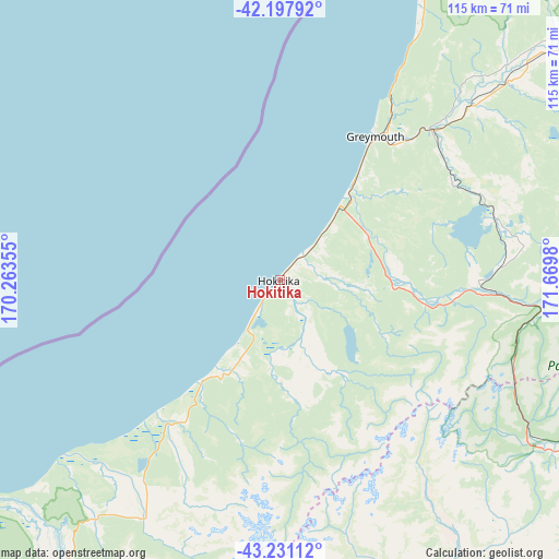
Hokitika GPS coordinates[2]
42° 43' 0.012" South, 170° 58' 0.012" East
| Map corner | latitude | longitude |
|---|---|---|
| Upper-left | -42.19792°, | 170.26355° |
| Center: | -42.71667°, | 170.96667° |
| Lower-right: | -43.23112°, | 171.6698° |
| Map W x H: | 114.9×114.9 km | = 71.4×71.4mi |
| max Lat: | -34.99604° ⇑73.9% North |
| Hokitika: | -42.71667° |
| min Lat: | ⇓26.1% South -46.6° |
| min Long | Hokitika | max Long |
| -176.55973° | 170.96667° | 178.33333° |
| W 14%⇐ | ⇒86% E |
Elevation
Elevation of Hokitika is 6 m = 20 ft, and this is 78.4 m = 257 ft below average elevation for this country.
| Max E: |
819 m = 2687 ft | 97.1% |
| Avg. | 84.4 m = 277 ft | |
| Hokitika | 6 m = 20 ft | |
Min E: |
3 m = 10 ft | 2.9% |
See also: New Zealand elevation on elevation.city.
Geographical zone
Hokitika is located in South temperate zone (between Tropic of Capricorn and the Antarctic Circle). Distance of this Southern Tropic circle is 2143.7 km =1332 mi to North.| Distance of | km | miles | from Hokitika |
|---|---|---|---|
| Equator | 4749.6 | 2951.3 | to North |
| Tropic Capricorn | 2143.7 | 1332 | to North |
| Antarctic Circle | 2651.5 | 1647.6 | to South |
| South Pole | 5257.4 | 3266.8 | to South |


Nearby cities:
15 places around Hokitika: (largest is in red/bold)
• Arthur’s Pass
55.4 km =34.4 mi,  117°
117°
• Ashburton
145.2 km =90.2 mi,  154°
154°
• Burnham
148.3 km =92.1 mi,  132°
132°
• Darfield
126.4 km =78.5 mi, 132°
• Dobson
40.3 km =25 mi,  42°
42°
• Gloriavale Christian Church
61.5 km =38.2 mi,  78°
78°
• Greymouth
33.7 km =20.9 mi,  34°
34°
• Methven
116 km =72.1 mi, 151°
• Oxford
118.3 km =73.5 mi, 123°
• Rakaia
143 km =88.9 mi,  143°
143°
• Reefton
99.5 km =61.8 mi,  47°
47°
• Rolleston
150 km =93.2 mi, 129°
• Sefton
150.5 km =93.5 mi,  113°
113°
• Tinwald
146.6 km =91.1 mi,  155°
155°
• Westport
119.3 km =74.1 mi, 26°
Sources, notices
• [Note1] Compared only with cities in New Zealand existing in our database
• [Src1] Map data: © OpenStreetMap contributors (CC-BY-SA)
• [Src2] Other city data from geonames.org with taken over terms of usage.
• [Src3] Geographical zone / Annual Mean Temperature by Robert A. Rohde @ Wikipedia
