Greymouth geodata
Greymouth (West Coast) is a seat of a first-order administrative division; located in New Zealand in Pacific/Auckland (GMT+12) time zone. With population of 9,419 people, there are 43 cities with bigger population in this country. Compared to other cities in New Zealand, 72.5% of cities are located further ↑North; 84.5% of cities are located further →East and 78.3% of cities have higher elevation than Greymouth. Note1


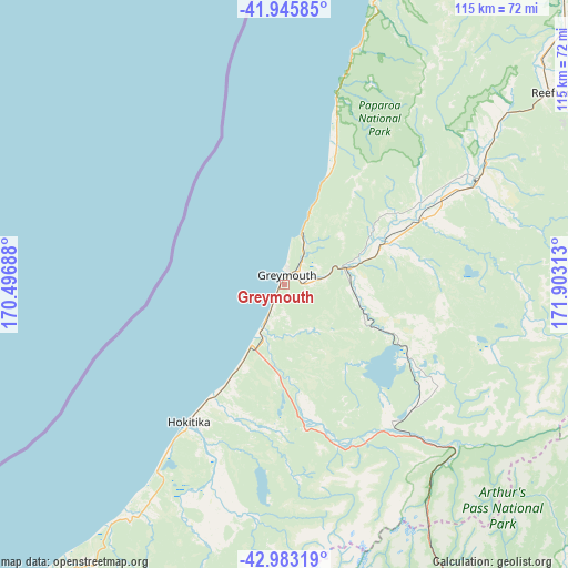
Greymouth GPS coordinates[2]
42° 28' 0.012" South, 171° 12' 0" East
| Map corner | latitude | longitude |
|---|---|---|
| Upper-left | -41.94585°, | 170.49688° |
| Center: | -42.46667°, | 171.2° |
| Lower-right: | -42.98319°, | 171.90313° |
| Map W x H: | 115.3×115.3 km | = 71.6×71.6mi |
| max Lat: | -34.99604° ⇑72.5% North |
| Greymouth: | -42.46667° |
| min Lat: | ⇓27.5% South -46.6° |
| min Long | Greymouth | max Long |
| -176.55973° | 171.2° | 178.33333° |
| W 15.5%⇐ | ⇒84.5% E |
Elevation
Elevation of Greymouth is 11 m = 36 ft, and this is 73.4 m = 241 ft below average elevation for this country.
| Max E: |
819 m = 2687 ft | 78.3% |
| Avg. | 84.4 m = 277 ft | |
| Greymouth | 11 m = 36 ft | |
Min E: |
3 m = 10 ft | 21.7% |
See also: New Zealand elevation on elevation.city.
Geographical zone
Greymouth is located in South temperate zone (between Tropic of Capricorn and the Antarctic Circle). Distance of this Southern Tropic circle is 2115.9 km =1314.8 mi to North.| Distance of | km | miles | from Greymouth |
|---|---|---|---|
| Equator | 4721.9 | 2934.1 | to North |
| Tropic Capricorn | 2115.9 | 1314.8 | to North |
| Antarctic Circle | 2679.3 | 1664.8 | to South |
| South Pole | 5285.2 | 3284.1 | to South |


Nearby cities:
15 places around Greymouth: (largest is in red/bold)
• Amberley
146.4 km =91 mi,  121°
121°
• Arthur’s Pass
61.5 km =38.2 mi,  150°
150°
• Darfield
135.4 km =84.1 mi, 146°
• Dobson
8.4 km =5.2 mi,  77°
77°
• Gloriavale Christian Church
44 km =27.3 mi,  110°
110°
• Hanmer Springs
132.7 km =82.5 mi,  92°
92°
• Hokitika
33.7 km =20.9 mi,  214°
214°
• Methven
134.8 km =83.8 mi,  164°
164°
• Murchison
119.3 km =74.1 mi,  51°
51°
• Oxford
122.5 km =76.1 mi,  139°
139°
• Reefton
67.2 km =41.8 mi, 54°
• Sefton
147.9 km =91.9 mi,  126°
126°
• Waikuku
152.3 km =94.6 mi, 127°
• Westport
86.1 km =53.5 mi,  22°
22°
• Woodend
152.3 km =94.6 mi, 128°
Sources, notices
• [Note1] Compared only with cities in New Zealand existing in our database
• [Src1] Map data: © OpenStreetMap contributors (CC-BY-SA)
• [Src2] Other city data from geonames.org with taken over terms of usage.
• [Src3] Geographical zone / Annual Mean Temperature by Robert A. Rohde @ Wikipedia
