Zapotillo geodata
Zapotillo (Veraguas) is a seat of a third-order administrative division; located in Panama in America/Panama (GMT-5) time zone. With population of 375 people, there are 529 cities with bigger population in this country. Compared to other cities in Panama, 81.4% of cities are located further ↑North; 70% of cities are located further →East and 62.1% of cities have higher elevation than Zapotillo. Note1


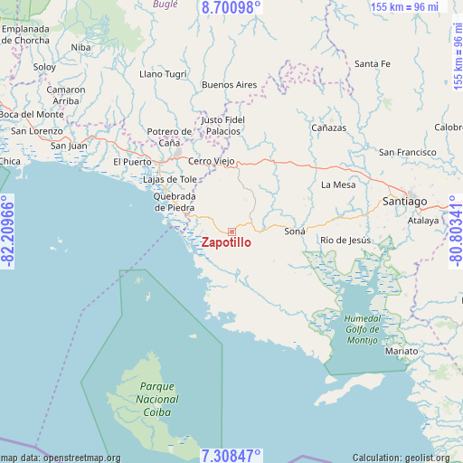
Zapotillo GPS coordinates[2]
8° 0' 19.152" North, 81° 30' 23.508" West
| Map corner | latitude | longitude |
|---|---|---|
| Upper-left | 8.70098°, | -82.20966° |
| Center: | 8.00532°, | -81.50653° |
| Lower-right: | 7.30847°, | -80.80341° |
| Map W x H: | 154.8×154.8 km | = 96.2×96.2mi |
| max Lat: | 9.60898° ⇑81.4% North |
| Zapotillo: | 8.00532° |
| min Lat: | ⇓18.6% South 7.26534° |
| min Long | Zapotillo | max Long |
| -82.91275° | -81.50653° | -77.38965° |
| W 30%⇐ | ⇒70% E |
Elevation
Elevation of Zapotillo is 49 m = 161 ft, and this is 123.1 m = 404 ft below average elevation for this country.
| Max E: |
2103 m = 6900 ft | 62.1% |
| Avg. | 172.1 m = 565 ft | |
| Zapotillo | 49 m = 161 ft | |
Min E: |
-1 m = -3 ft | 37.9% |
See also: Panama elevation on elevation.city.
Geographical zone
Zapotillo is located in North Torrid zone (between Equator and Tropic of Cancer). Distance of Equator is 890.1 km =553.1 mi to South.| Distance of | km | miles | from Zapotillo |
|---|---|---|---|
| North Pole | 9117 | 5665 | to North |
| Arctic Circle | 6511.1 | 4045.8 | to North |
| Tropic Cancer | 1715.8 | 1066.1 | to North |
| Equator | 890.1 | 553.1 | to South |


Nearby cities:
15 places around Zapotillo: (largest is in red/bold)
• Calidonia
14.3 km =8.9 mi,  111°
111°
• Cerro Pelado
17.8 km =11.1 mi,  348°
348°
• Corozal
10.8 km =6.7 mi,  42°
42°
• El María
7.4 km =4.6 mi,  69°
69°
• El Piro
22.8 km =14.2 mi, 354°
• El Rincón
21.5 km =13.4 mi,  22°
22°
• La Tollosa
20.2 km =12.6 mi,  95°
95°
• Las Palmas
15.5 km =9.6 mi, 20°
• Lolá
10.5 km =6.5 mi, 21°
• Puerto Vidal
11.8 km =7.3 mi,  293°
293°
• Quebrada de Oro
13.6 km =8.5 mi,  75°
75°
• Quebrada de Piedra
21.4 km =13.3 mi,  297°
297°
• San Francisco
16.8 km =10.4 mi, 66°
• Soná
20.4 km =12.7 mi,  87°
87°
• Tríbique
21.1 km =13.1 mi, 93°
Sources, notices
• [Note1] Compared only with cities in Panama existing in our database
• [Src1] Map data: © OpenStreetMap contributors (CC-BY-SA)
• [Src2] Other city data from geonames.org with taken over terms of usage.
• [Src3] Geographical zone / Annual Mean Temperature by Robert A. Rohde @ Wikipedia
