Lolá geodata
Lolá (Veraguas) is a seat of a third-order administrative division; located in Panama in America/Panama (GMT-5) time zone. With population of 364 people, there are 532 cities with bigger population in this country. Compared to other cities in Panama, 77.3% of cities are located further ↑North; 69.3% of cities are located further →East and 91.7% of cities have lower elevation than Lolá. Note1


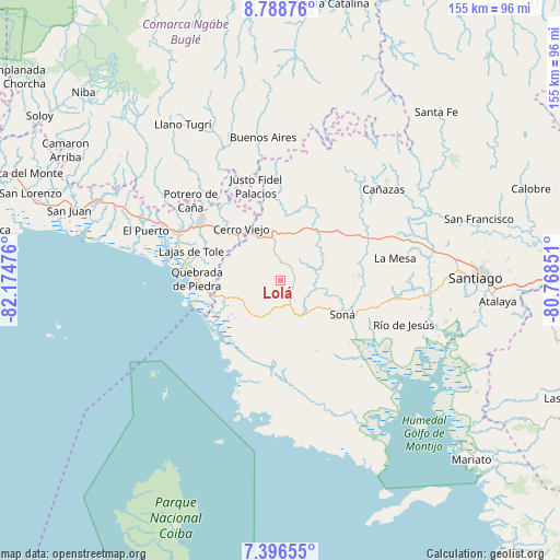
Lolá GPS coordinates[2]
8° 5' 35.736" North, 81° 28' 17.868" West
| Map corner | latitude | longitude |
|---|---|---|
| Upper-left | 8.78876°, | -82.17476° |
| Center: | 8.09326°, | -81.47163° |
| Lower-right: | 7.39655°, | -80.76851° |
| Map W x H: | 154.8×154.8 km | = 96.2×96.2mi |
| max Lat: | 9.60898° ⇑77.3% North |
| Lolá: | 8.09326° |
| min Lat: | ⇓22.7% South 7.26534° |
| min Long | Lolá | max Long |
| -82.91275° | -81.47163° | -77.38965° |
| W 30.7%⇐ | ⇒69.3% E |
Elevation
Elevation of Lolá is 478 m = 1568 ft, and this is 305.9 m = 1004 ft above average elevation for this country.
| Max E: |
2103 m = 6900 ft | 8.3% |
| Lolá | 478 m 1568 ft | |
| Avg. | 172.1 m = 565 ft | |
Min E: |
-1 m = -3 ft | 91.7% |
See also: Panama elevation on elevation.city.
Geographical zone
Lolá is located in North Torrid zone (between Equator and Tropic of Cancer). Distance of Equator is 899.9 km =559.2 mi to South.| Distance of | km | miles | from Lolá |
|---|---|---|---|
| North Pole | 9107.2 | 5658.9 | to North |
| Arctic Circle | 6501.3 | 4039.7 | to North |
| Tropic Cancer | 1706 | 1060.1 | to North |
| Equator | 899.9 | 559.2 | to South |


Nearby cities:
15 places around Lolá: (largest is in red/bold)
• Calidonia
17.8 km =11.1 mi,  148°
148°
• Cerro Pelado
10.7 km =6.6 mi,  315°
315°
• Cerro Venado
18.8 km =11.7 mi, 323°
• Corozal
3.9 km =2.4 mi,  117°
117°
• El María
7.8 km =4.8 mi,  156°
156°
• El Piro
14.3 km =8.9 mi,  334°
334°
• El Prado
16.4 km =10.2 mi,  347°
347°
• El Rincón
11 km =6.8 mi,  22°
22°
• Las Palmas
5 km =3.1 mi, 19°
• Puerto Vidal
15.5 km =9.6 mi,  251°
251°
• Quebrada de Oro
11.3 km =7 mi, 124°
• Rodeo Viejo
17.2 km =10.7 mi,  83°
83°
• San Francisco
11.9 km =7.4 mi,  104°
104°
• Soná
18.8 km =11.7 mi, 118°
• Zapotillo
10.5 km =6.5 mi,  201°
201°
Sources, notices
• [Note1] Compared only with cities in Panama existing in our database
• [Src1] Map data: © OpenStreetMap contributors (CC-BY-SA)
• [Src2] Other city data from geonames.org with taken over terms of usage.
• [Src3] Geographical zone / Annual Mean Temperature by Robert A. Rohde @ Wikipedia
