El María geodata
El María (Veraguas) is a seat of a third-order administrative division; located in Panama in America/Panama (GMT-5) time zone. With population of 87 people, there are 666 cities with bigger population in this country. Compared to other cities in Panama, 80.1% of cities are located further ↑North; 68.9% of cities are located further →East and 74.6% of cities have lower elevation than El María. Note1


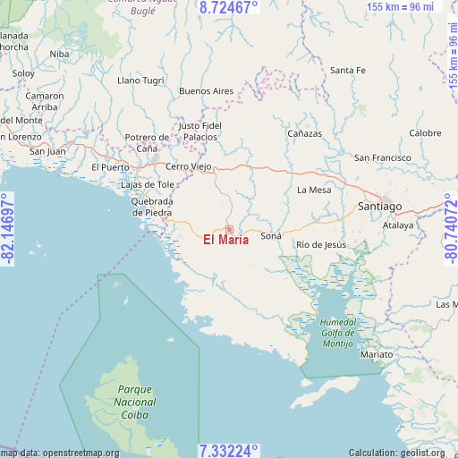
El María GPS coordinates[2]
8° 1' 44.58" North, 81° 26' 37.824" West
| Map corner | latitude | longitude |
|---|---|---|
| Upper-left | 8.72467°, | -82.14697° |
| Center: | 8.02905°, | -81.44384° |
| Lower-right: | 7.33224°, | -80.74072° |
| Map W x H: | 154.8×154.8 km | = 96.2×96.2mi |
| max Lat: | 9.60898° ⇑80.1% North |
| El María: | 8.02905° |
| min Lat: | ⇓19.9% South 7.26534° |
| min Long | El María | max Long |
| -82.91275° | -81.44384° | -77.38965° |
| W 31.1%⇐ | ⇒68.9% E |
Elevation
Elevation of El María is 201 m = 659 ft, and this is 28.9 m = 95 ft above average elevation for this country.
| Max E: |
2103 m = 6900 ft | 25.4% |
| El María | 201 m 659 ft | |
| Avg. | 172.1 m = 565 ft | |
Min E: |
-1 m = -3 ft | 74.6% |
See also: Panama elevation on elevation.city.
Geographical zone
El María is located in North Torrid zone (between Equator and Tropic of Cancer). Distance of Equator is 892.7 km =554.7 mi to South.| Distance of | km | miles | from El María |
|---|---|---|---|
| North Pole | 9114.3 | 5663.4 | to North |
| Arctic Circle | 6508.4 | 4044.1 | to North |
| Tropic Cancer | 1713.2 | 1064.5 | to North |
| Equator | 892.7 | 554.7 | to South |


Nearby cities:
15 places around El María: (largest is in red/bold)
• Calidonia
10.2 km =6.3 mi,  141°
141°
• Cerro Pelado
18.2 km =11.3 mi,  324°
324°
• Corozal
5.4 km =3.4 mi,  4°
4°
• El Piro
22 km =13.7 mi,  335°
335°
• El Rincón
17.3 km =10.7 mi, 3°
• La Tollosa
14 km =8.7 mi,  108°
108°
• Las Palmas
11.9 km =7.4 mi,  353°
353°
• Lolá
7.8 km =4.8 mi, 336°
• Puerto Vidal
17.9 km =11.1 mi,  276°
276°
• Quebrada de Oro
6.3 km =3.9 mi,  83°
83°
• Rodeo Viejo
16.8 km =10.4 mi,  56°
56°
• San Francisco
9.5 km =5.9 mi, 63°
• Soná
13.6 km =8.5 mi,  97°
97°
• Tríbique
14.7 km =9.1 mi, 104°
• Zapotillo
7.4 km =4.6 mi,  249°
249°
Sources, notices
• [Note1] Compared only with cities in Panama existing in our database
• [Src1] Map data: © OpenStreetMap contributors (CC-BY-SA)
• [Src2] Other city data from geonames.org with taken over terms of usage.
• [Src3] Geographical zone / Annual Mean Temperature by Robert A. Rohde @ Wikipedia
