Corozal geodata
Corozal (Veraguas) is a seat of a third-order administrative division; located in Panama in America/Panama (GMT-5) time zone. With population of 189 people, there are 609 cities with bigger population in this country. Compared to other cities in Panama, 78% of cities are located further ↑North; 68.8% of cities are located further →East and 75.4% of cities have lower elevation than Corozal. Note1


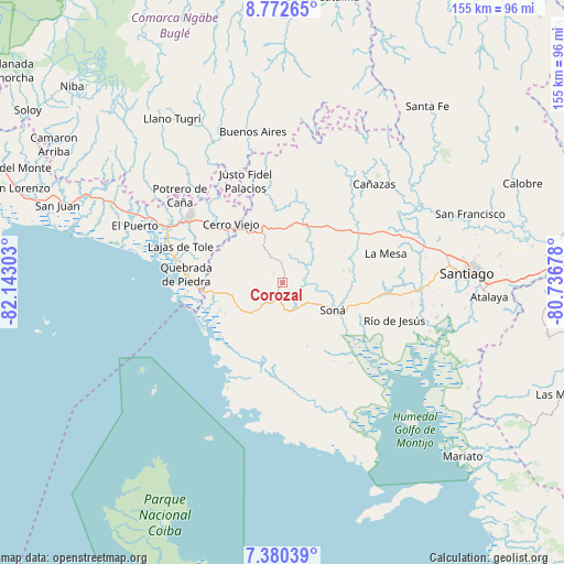
Corozal GPS coordinates[2]
8° 4' 37.632" North, 81° 26' 23.64" West
| Map corner | latitude | longitude |
|---|---|---|
| Upper-left | 8.77265°, | -82.14303° |
| Center: | 8.07712°, | -81.4399° |
| Lower-right: | 7.38039°, | -80.73678° |
| Map W x H: | 154.8×154.8 km | = 96.2×96.2mi |
| max Lat: | 9.60898° ⇑78% North |
| Corozal: | 8.07712° |
| min Lat: | ⇓22% South 7.26534° |
| min Long | Corozal | max Long |
| -82.91275° | -81.4399° | -77.38965° |
| W 31.2%⇐ | ⇒68.8% E |
Elevation
Elevation of Corozal is 204 m = 669 ft, and this is 31.9 m = 105 ft above average elevation for this country.
| Max E: |
2103 m = 6900 ft | 24.6% |
| Corozal | 204 m 669 ft | |
| Avg. | 172.1 m = 565 ft | |
Min E: |
-1 m = -3 ft | 75.4% |
See also: Panama elevation on elevation.city.
Geographical zone
Corozal is located in North Torrid zone (between Equator and Tropic of Cancer). Distance of Equator is 898.1 km =558.1 mi to South.| Distance of | km | miles | from Corozal |
|---|---|---|---|
| North Pole | 9109 | 5660.1 | to North |
| Arctic Circle | 6503.1 | 4040.8 | to North |
| Tropic Cancer | 1707.8 | 1061.2 | to North |
| Equator | 898.1 | 558.1 | to South |


Nearby cities:
15 places around Corozal: (largest is in red/bold)
• Boró
18.4 km =11.4 mi,  56°
56°
• Calidonia
14.5 km =9 mi,  156°
156°
• Cerro Pelado
14.5 km =9 mi,  310°
310°
• El María
5.4 km =3.4 mi,  184°
184°
• El Piro
17.6 km =10.9 mi,  326°
326°
• El Rincón
11.9 km =7.4 mi,  3°
3°
• La Tollosa
16.1 km =10 mi,  127°
127°
• Las Palmas
6.8 km =4.2 mi,  344°
344°
• Lolá
3.9 km =2.4 mi,  297°
297°
• Quebrada de Oro
7.4 km =4.6 mi, 128°
• Rodeo Viejo
14.1 km =8.8 mi,  74°
74°
• San Francisco
8.1 km =5 mi,  98°
98°
• Soná
14.9 km =9.3 mi,  118°
118°
• Tríbique
16.5 km =10.3 mi, 123°
• Zapotillo
10.8 km =6.7 mi,  222°
222°
Sources, notices
• [Note1] Compared only with cities in Panama existing in our database
• [Src1] Map data: © OpenStreetMap contributors (CC-BY-SA)
• [Src2] Other city data from geonames.org with taken over terms of usage.
• [Src3] Geographical zone / Annual Mean Temperature by Robert A. Rohde @ Wikipedia
