Sioguí Arriba geodata
Sioguí Arriba (Chiriquí) is a populated place; located in Panama in America/Panama (GMT-5) time zone. With population of 1,112 people, there are 221 cities with bigger population in this country. Compared to other cities in Panama, 57.8% of cities are located further ↓South; 94% of cities are located further →East and 82.4% of cities have lower elevation than Sioguí Arriba. Note1


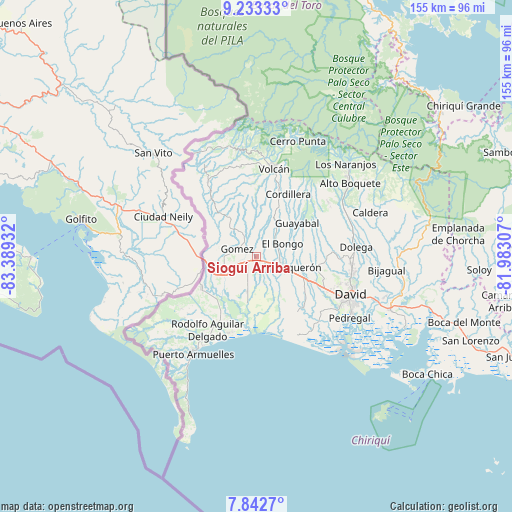
Sioguí Arriba GPS coordinates[2]
8° 32' 19.14" North, 82° 41' 10.284" West
| Map corner | latitude | longitude |
|---|---|---|
| Upper-left | 9.23333°, | -83.38932° |
| Center: | 8.53865°, | -82.68619° |
| Lower-right: | 7.8427°, | -81.98307° |
| Map W x H: | 154.6×154.6 km | = 96.1×96.1mi |
| max Lat: | 9.60898° ⇑42.2% North |
| Sioguí Arriba: | 8.53865° |
| min Lat: | ⇓57.8% South 7.26534° |
| min Long | Sioguí Arriba | max Long |
| -82.91275° | -82.68619° | -77.38965° |
| W 6%⇐ | ⇒94% E |
Elevation
Elevation of Sioguí Arriba is 294 m = 965 ft, and this is 121.9 m = 400 ft above average elevation for this country.
| Max E: |
2103 m = 6900 ft | 17.6% |
| Sioguí Arriba | 294 m 965 ft | |
| Avg. | 172.1 m = 565 ft | |
Min E: |
-1 m = -3 ft | 82.4% |
See also: Panama elevation on elevation.city.
Geographical zone
Sioguí Arriba is located in North Torrid zone (between Equator and Tropic of Cancer). Distance of Equator is 949.4 km =589.9 mi to South.| Distance of | km | miles | from Sioguí Arriba |
|---|---|---|---|
| North Pole | 9057.7 | 5628.2 | to North |
| Arctic Circle | 6451.8 | 4009 | to North |
| Tropic Cancer | 1656.5 | 1029.3 | to North |
| Equator | 949.4 | 589.9 | to South |


Nearby cities:
15 places around Sioguí Arriba: (largest is in red/bold)
• Bongo Arriba
8.9 km =5.5 mi,  51°
51°
• Bugaba
9.6 km =6 mi,  130°
130°
• Bugabita Arriba
5.8 km =3.6 mi,  109°
109°
• El Santo
2.7 km =1.7 mi,  15°
15°
• Gómez
6.6 km =4.1 mi,  292°
292°
• La Concepción
8 km =5 mi, 111°
• La Estrella
3 km =1.9 mi,  148°
148°
• San Andrés
8.3 km =5.2 mi,  328°
328°
• San Miguel del Yuco
6.7 km =4.2 mi,  82°
82°
• San Vicente
7.9 km =4.9 mi,  43°
43°
• Santa Marta
3.1 km =1.9 mi,  206°
206°
• Santa Rosa
6.8 km =4.2 mi,  1°
1°
• Santo Domingo
4.5 km =2.8 mi,  220°
220°
• Sioguí Abajo
6.2 km =3.9 mi,  158°
158°
• Sortova
3.9 km =2.4 mi, 77°
Sources, notices
• [Note1] Compared only with cities in Panama existing in our database
• [Src1] Map data: © OpenStreetMap contributors (CC-BY-SA)
• [Src2] Other city data from geonames.org with taken over terms of usage.
• [Src3] Geographical zone / Annual Mean Temperature by Robert A. Rohde @ Wikipedia
