San Miguel del Yuco geodata
San Miguel del Yuco (Chiriquí) is a populated place; located in Panama in America/Panama (GMT-5) time zone. With population of 756 people, there are 338 cities with bigger population in this country. Compared to other cities in Panama, 58.8% of cities are located further ↓South; 92.4% of cities are located further →East and 84.1% of cities have lower elevation than San Miguel del Yuco. Note1


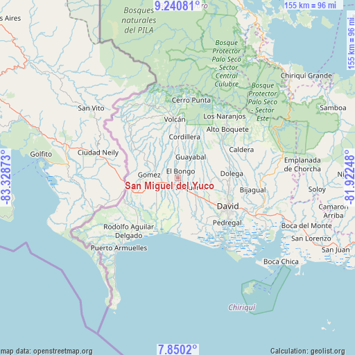
San Miguel del Yuco GPS coordinates[2]
8° 32' 46.104" North, 82° 37' 32.16" West
| Map corner | latitude | longitude |
|---|---|---|
| Upper-left | 9.24081°, | -83.32873° |
| Center: | 8.54614°, | -82.6256° |
| Lower-right: | 7.8502°, | -81.92248° |
| Map W x H: | 154.6×154.6 km | = 96.1×96.1mi |
| max Lat: | 9.60898° ⇑41.2% North |
| San Miguel del Yuco: | 8.54614° |
| min Lat: | ⇓58.8% South 7.26534° |
| min Long | San Miguel del | max Long |
| -82.91275° | -82.6256° | -77.38965° |
| W 7.6%⇐ | ⇒92.4% E |
Elevation
Elevation of San Miguel del Yuco is 327 m = 1073 ft, and this is 154.9 m = 508 ft above average elevation for this country.
| Max E: |
2103 m = 6900 ft | 15.9% |
| San Miguel del Yuco | 327 m 1073 ft | |
| Avg. | 172.1 m = 565 ft | |
Min E: |
-1 m = -3 ft | 84.1% |
See also: Panama elevation on elevation.city.
Geographical zone
San Miguel del Yuco is located in North Torrid zone (between Equator and Tropic of Cancer). Distance of Equator is 950.2 km =590.4 mi to South.| Distance of | km | miles | from San Miguel del Yuco |
|---|---|---|---|
| North Pole | 9056.8 | 5627.6 | to North |
| Arctic Circle | 6450.9 | 4008.4 | to North |
| Tropic Cancer | 1655.7 | 1028.8 | to North |
| Equator | 950.2 | 590.4 | to South |


Nearby cities:
15 places around San Miguel del Yuco: (largest is in red/bold)
• Bongo Arriba
4.8 km =3 mi,  4°
4°
• Boquerón
7.6 km =4.7 mi,  126°
126°
• Bugaba
7.1 km =4.4 mi,  174°
174°
• Bugabita Arriba
3 km =1.9 mi,  203°
203°
• Chacarero
7 km =4.3 mi,  154°
154°
• El Santo
6.2 km =3.9 mi,  286°
286°
• La Concepción
3.9 km =2.4 mi, 168°
• La Estrella
6.1 km =3.8 mi,  236°
236°
• La Meseta
3.5 km =2.2 mi,  76°
76°
• San Vicente
5.1 km =3.2 mi,  345°
345°
• Santa Marta
8.8 km =5.5 mi,  246°
246°
• Santa Rosa
8.8 km =5.5 mi,  312°
312°
• Sioguí Abajo
7.9 km =4.9 mi,  213°
213°
• Sioguí Arriba
6.7 km =4.2 mi,  262°
262°
• Sortova
2.9 km =1.8 mi,  270°
270°
Sources, notices
• [Note1] Compared only with cities in Panama existing in our database
• [Src1] Map data: © OpenStreetMap contributors (CC-BY-SA)
• [Src2] Other city data from geonames.org with taken over terms of usage.
• [Src3] Geographical zone / Annual Mean Temperature by Robert A. Rohde @ Wikipedia
