San Andrés geodata
San Andrés (Chiriquí) is a seat of a third-order administrative division; located in Panama in America/Panama (GMT-5) time zone. With population of 1,152 people, there are 211 cities with bigger population in this country. Compared to other cities in Panama, 64.1% of cities are located further ↓South; 94.6% of cities are located further →East and 92.9% of cities have lower elevation than San Andrés. Note1


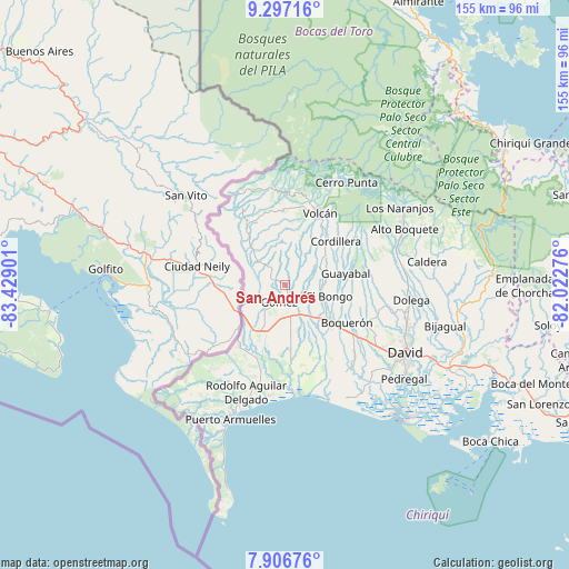
San Andrés GPS coordinates[2]
8° 36' 9.36" North, 82° 43' 33.168" West
| Map corner | latitude | longitude |
|---|---|---|
| Upper-left | 9.29716°, | -83.42901° |
| Center: | 8.6026°, | -82.72588° |
| Lower-right: | 7.90676°, | -82.02276° |
| Map W x H: | 154.6×154.6 km | = 96.1×96.1mi |
| max Lat: | 9.60898° ⇑35.9% North |
| San Andrés: | 8.6026° |
| min Lat: | ⇓64.1% South 7.26534° |
| min Long | San Andrés | max Long |
| -82.91275° | -82.72588° | -77.38965° |
| W 5.4%⇐ | ⇒94.6% E |
Elevation
Elevation of San Andrés is 522 m = 1713 ft, and this is 349.9 m = 1148 ft above average elevation for this country.
| Max E: |
2103 m = 6900 ft | 7.1% |
| San Andrés | 522 m 1713 ft | |
| Avg. | 172.1 m = 565 ft | |
Min E: |
-1 m = -3 ft | 92.9% |
See also: Panama elevation on elevation.city.
Geographical zone
San Andrés is located in North Torrid zone (between Equator and Tropic of Cancer). Distance of Equator is 956.5 km =594.3 mi to South.| Distance of | km | miles | from San Andrés |
|---|---|---|---|
| North Pole | 9050.5 | 5623.7 | to North |
| Arctic Circle | 6444.7 | 4004.5 | to North |
| Tropic Cancer | 1649.4 | 1024.9 | to North |
| Equator | 956.5 | 594.3 | to South |


Nearby cities:
15 places around San Andrés: (largest is in red/bold)
• Breñón
9.9 km =6.2 mi,  284°
284°
• Celmira
10.7 km =6.6 mi,  229°
229°
• El Santo
6.8 km =4.2 mi,  131°
131°
• Gómez
4.9 km =3 mi,  200°
200°
• La Bonita
4.6 km =2.9 mi,  293°
293°
• La Estrella
11.3 km =7 mi,  148°
148°
• Portón
8 km =5 mi, 234°
• San Francisco
3.5 km =2.2 mi,  355°
355°
• San Vicente
9.9 km =6.2 mi,  97°
97°
• Santa Cruz
5.8 km =3.6 mi,  320°
320°
• Santa Marta
10.3 km =6.4 mi,  163°
163°
• Santa Rosa
4.5 km =2.8 mi,  94°
94°
• Santo Domingo
10.6 km =6.6 mi,  172°
172°
• Sioguí Arriba
8.3 km =5.2 mi, 148°
• Sortova
10.3 km =6.4 mi, 127°
Sources, notices
• [Note1] Compared only with cities in Panama existing in our database
• [Src1] Map data: © OpenStreetMap contributors (CC-BY-SA)
• [Src2] Other city data from geonames.org with taken over terms of usage.
• [Src3] Geographical zone / Annual Mean Temperature by Robert A. Rohde @ Wikipedia
