La Estrella geodata
La Estrella (Chiriquí) is a seat of a third-order administrative division; located in Panama in America/Panama (GMT-5) time zone. With population of 885 people, there are 286 cities with bigger population in this country. Compared to other cities in Panama, 54.7% of cities are located further ↓South; 93.5% of cities are located further →East and 78.3% of cities have lower elevation than La Estrella. Note1


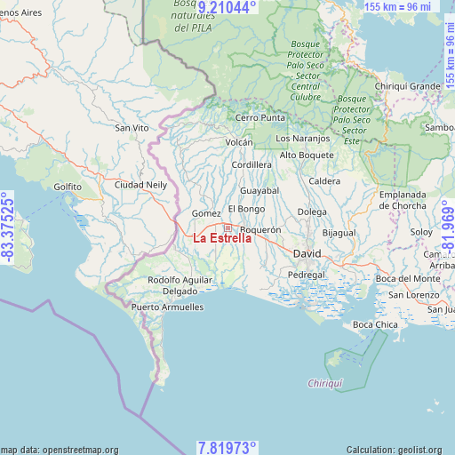
La Estrella GPS coordinates[2]
8° 30' 56.592" North, 82° 40' 19.632" West
| Map corner | latitude | longitude |
|---|---|---|
| Upper-left | 9.21044°, | -83.37525° |
| Center: | 8.51572°, | -82.67212° |
| Lower-right: | 7.81973°, | -81.969° |
| Map W x H: | 154.6×154.6 km | = 96.1×96.1mi |
| max Lat: | 9.60898° ⇑45.3% North |
| La Estrella: | 8.51572° |
| min Lat: | ⇓54.7% South 7.26534° |
| min Long | La Estrella | max Long |
| -82.91275° | -82.67212° | -77.38965° |
| W 6.5%⇐ | ⇒93.5% E |
Elevation
Elevation of La Estrella is 235 m = 771 ft, and this is 62.9 m = 206 ft above average elevation for this country.
| Max E: |
2103 m = 6900 ft | 21.7% |
| La Estrella | 235 m 771 ft | |
| Avg. | 172.1 m = 565 ft | |
Min E: |
-1 m = -3 ft | 78.3% |
See also: Panama elevation on elevation.city.
Geographical zone
La Estrella is located in North Torrid zone (between Equator and Tropic of Cancer). Distance of Equator is 946.9 km =588.4 mi to South.| Distance of | km | miles | from La Estrella |
|---|---|---|---|
| North Pole | 9060.2 | 5629.7 | to North |
| Arctic Circle | 6454.3 | 4010.5 | to North |
| Tropic Cancer | 1659.1 | 1030.9 | to North |
| Equator | 946.9 | 588.4 | to South |


Nearby cities:
15 places around La Estrella: (largest is in red/bold)
• Bugaba
6.8 km =4.2 mi,  122°
122°
• Bugabita Arriba
4 km =2.5 mi,  80°
80°
• Chacarero
8.6 km =5.3 mi,  110°
110°
• El Santo
5.2 km =3.2 mi,  350°
350°
• Gómez
9.1 km =5.7 mi,  303°
303°
• La Concepción
5.9 km =3.7 mi,  93°
93°
• La Meseta
9.5 km =5.9 mi,  63°
63°
• San Miguel del Yuco
6.1 km =3.8 mi, 56°
• San Vicente
9.2 km =5.7 mi,  25°
25°
• Santa Marta
2.9 km =1.8 mi,  266°
266°
• Santa Rosa
9.4 km =5.8 mi, 351°
• Santo Domingo
4.6 km =2.9 mi,  259°
259°
• Sioguí Abajo
3.3 km =2.1 mi,  167°
167°
• Sioguí Arriba
3 km =1.9 mi,  328°
328°
• Sortova
4.1 km =2.5 mi, 33°
Sources, notices
• [Note1] Compared only with cities in Panama existing in our database
• [Src1] Map data: © OpenStreetMap contributors (CC-BY-SA)
• [Src2] Other city data from geonames.org with taken over terms of usage.
• [Src3] Geographical zone / Annual Mean Temperature by Robert A. Rohde @ Wikipedia
