Bugaba geodata
Bugaba (Chiriquí) is a seat of a third-order administrative division; located in Panama in America/Panama (GMT-5) time zone. With population of 3,263 people, there are 88 cities with bigger population in this country. Compared to other cities in Panama, 51.4% of cities are located further ↓South; 92.2% of cities are located further →East and 68.5% of cities have lower elevation than Bugaba. Note1


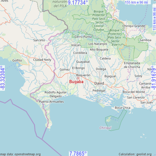
Bugaba GPS coordinates[2]
8° 28' 57.18" North, 82° 37' 11.676" West
| Map corner | latitude | longitude |
|---|---|---|
| Upper-left | 9.17734°, | -83.32304° |
| Center: | 8.48255°, | -82.61991° |
| Lower-right: | 7.7865°, | -81.91679° |
| Map W x H: | 154.6×154.6 km | = 96.1×96.1mi |
| max Lat: | 9.60898° ⇑48.6% North |
| Bugaba: | 8.48255° |
| min Lat: | ⇓51.4% South 7.26534° |
| min Long | Bugaba | max Long |
| -82.91275° | -82.61991° | -77.38965° |
| W 7.8%⇐ | ⇒92.2% E |
Elevation
Elevation of Bugaba is 144 m = 472 ft, and this is 28.1 m = 92 ft below average elevation for this country.
| Max E: |
2103 m = 6900 ft | 31.5% |
| Avg. | 172.1 m = 565 ft | |
| Bugaba | 144 m = 472 ft | |
Min E: |
-1 m = -3 ft | 68.5% |
See also: Panama elevation on elevation.city.
Geographical zone
Bugaba is located in North Torrid zone (between Equator and Tropic of Cancer). Distance of Equator is 943.2 km =586.1 mi to South.| Distance of | km | miles | from Bugaba |
|---|---|---|---|
| North Pole | 9063.9 | 5632 | to North |
| Arctic Circle | 6458 | 4012.8 | to North |
| Tropic Cancer | 1662.7 | 1033.2 | to North |
| Equator | 943.2 | 586.1 | to South |


Nearby cities:
15 places around Bugaba: (largest is in red/bold)
• Boquerón
6 km =3.7 mi,  65°
65°
• Bugabita Arriba
4.7 km =2.9 mi,  337°
337°
• Chacarero
2.5 km =1.6 mi, 73°
• El Tejar
7.8 km =4.8 mi,  138°
138°
• La Concepción
3.3 km =2.1 mi,  2°
2°
• La Estrella
6.8 km =4.2 mi,  302°
302°
• La Meseta
8.3 km =5.2 mi,  19°
19°
• Loma de San Pedro
9.8 km =6.1 mi,  130°
130°
• San Miguel del Yuco
7.1 km =4.4 mi,  354°
354°
• Santa Marta
9.3 km =5.8 mi,  292°
292°
• Sioguí Abajo
5 km =3.1 mi,  275°
275°
• Sioguí Arriba
9.6 km =6 mi,  310°
310°
• Sortova
7.9 km =4.9 mi,  333°
333°
• Tijeras
6.6 km =4.1 mi,  97°
97°
• Veladero
8 km =5 mi, 133°
Sources, notices
• [Note1] Compared only with cities in Panama existing in our database
• [Src1] Map data: © OpenStreetMap contributors (CC-BY-SA)
• [Src2] Other city data from geonames.org with taken over terms of usage.
• [Src3] Geographical zone / Annual Mean Temperature by Robert A. Rohde @ Wikipedia
