San Miguel geodata
San Miguel (Panamá) is a populated place; located in Panama in America/Panama (GMT-5) time zone. With population of 532 people, there are 458 cities with bigger population in this country. Compared to other cities in Panama, 92.2% of cities are located further ↓South; 90.4% of cities are located further ←West and 71.4% of cities have lower elevation than San Miguel. Note1


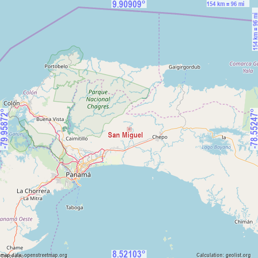
San Miguel GPS coordinates[2]
9° 12' 56.664" North, 79° 15' 20.124" West
| Map corner | latitude | longitude |
|---|---|---|
| Upper-left | 9.90909°, | -79.95872° |
| Center: | 9.21574°, | -79.25559° |
| Lower-right: | 8.52103°, | -78.55247° |
| Map W x H: | 154.3×154.3 km | = 95.9×95.9mi |
| max Lat: | 9.60898° ⇑7.8% North |
| San Miguel: | 9.21574° |
| min Lat: | ⇓92.2% South 7.26534° |
| min Long | San Miguel | max Long |
| -82.91275° | -79.25559° | -77.38965° |
| W 90.4%⇐ | ⇒9.6% E |
Elevation
Elevation of San Miguel is 168 m = 551 ft, and this is 4.1 m = 13 ft below average elevation for this country.
| Max E: |
2103 m = 6900 ft | 28.6% |
| Avg. | 172.1 m = 565 ft | |
| San Miguel | 168 m = 551 ft | |
Min E: |
-1 m = -3 ft | 71.4% |
See also: Panama elevation on elevation.city.
Geographical zone
San Miguel is located in North Torrid zone (between Equator and Tropic of Cancer). Distance of Equator is 1024.7 km =636.7 mi to South.| Distance of | km | miles | from San Miguel |
|---|---|---|---|
| North Pole | 8982.4 | 5581.4 | to North |
| Arctic Circle | 6376.5 | 3962.2 | to North |
| Tropic Cancer | 1581.2 | 982.5 | to North |
| Equator | 1024.7 | 636.7 | to South |


Nearby cities:
15 places around San Miguel: (largest is in red/bold)
• Cabra Número Uno
14.9 km =9.3 mi,  216°
216°
• Cerro Azul
19.3 km =12 mi,  250°
250°
• Chepo
17.7 km =11 mi,  106°
106°
• El Progreso
16.3 km =10.1 mi,  69°
69°
• Juan Gil
4.2 km =2.6 mi,  180°
180°
• La Mesa
5.2 km =3.2 mi,  203°
203°
• Las Margaritas
18.8 km =11.7 mi,  100°
100°
• Los Lotes
10.8 km =6.7 mi, 199°
• Naranjal
10.1 km =6.3 mi,  164°
164°
• Nueva Esperanza
15.3 km =9.5 mi,  214°
214°
• Pacora
15.6 km =9.7 mi,  193°
193°
• Paso Blanco
9.9 km =6.2 mi,  173°
173°
• Rancho Café
16.3 km =10.1 mi,  231°
231°
• Unión de Azuero
11.7 km =7.3 mi,  126°
126°
• Vista Hermosa
16.4 km =10.2 mi, 225°
Sources, notices
• [Note1] Compared only with cities in Panama existing in our database
• [Src1] Map data: © OpenStreetMap contributors (CC-BY-SA)
• [Src2] Other city data from geonames.org with taken over terms of usage.
• [Src3] Geographical zone / Annual Mean Temperature by Robert A. Rohde @ Wikipedia
