San Lorenzo geodata
San Lorenzo (Chiriquí) is a seat of a third-order administrative division; located in Panama in America/Panama (GMT-5) time zone. With population of 1,025 people, there are 250 cities with bigger population in this country. Compared to other cities in Panama, 65.9% of cities are located further ↑North; 79.6% of cities are located further →East and 68% of cities have higher elevation than San Lorenzo. Note1


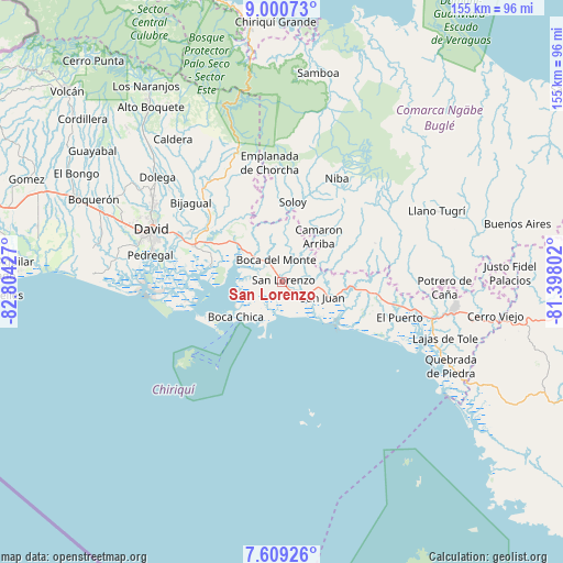
San Lorenzo GPS coordinates[2]
8° 18' 20.196" North, 82° 6' 4.104" West
| Map corner | latitude | longitude |
|---|---|---|
| Upper-left | 9.00073°, | -82.80427° |
| Center: | 8.30561°, | -82.10114° |
| Lower-right: | 7.60926°, | -81.39802° |
| Map W x H: | 154.7×154.7 km | = 96.1×96.1mi |
| max Lat: | 9.60898° ⇑65.9% North |
| San Lorenzo: | 8.30561° |
| min Lat: | ⇓34.1% South 7.26534° |
| min Long | San Lorenzo | max Long |
| -82.91275° | -82.10114° | -77.38965° |
| W 20.4%⇐ | ⇒79.6% E |
Elevation
Elevation of San Lorenzo is 38 m = 125 ft, and this is 134.1 m = 440 ft below average elevation for this country.
| Max E: |
2103 m = 6900 ft | 68% |
| Avg. | 172.1 m = 565 ft | |
| San Lorenzo | 38 m = 125 ft | |
Min E: |
-1 m = -3 ft | 32% |
See also: Panama elevation on elevation.city.
Geographical zone
San Lorenzo is located in North Torrid zone (between Equator and Tropic of Cancer). Distance of Equator is 923.5 km =573.8 mi to South.| Distance of | km | miles | from San Lorenzo |
|---|---|---|---|
| North Pole | 9083.6 | 5644.3 | to North |
| Arctic Circle | 6477.7 | 4025.1 | to North |
| Tropic Cancer | 1682.4 | 1045.4 | to North |
| Equator | 923.5 | 573.8 | to South |


Nearby cities:
15 places around San Lorenzo: (largest is in red/bold)
• Boca Chica
15.9 km =9.9 mi,  232°
232°
• Boca del Monte
5.4 km =3.4 mi,  345°
345°
• Camarón Arriba
14.7 km =9.1 mi,  53°
53°
• Cerro Banco
18.6 km =11.6 mi,  24°
24°
• Hato Corotú
14.8 km =9.2 mi,  77°
77°
• Horconcitos
5.5 km =3.4 mi,  276°
276°
• Juay
17.2 km =10.7 mi,  97°
97°
• Plan de Chorcha
18.5 km =11.5 mi,  339°
339°
• Pueblito
14.8 km =9.2 mi,  109°
109°
• Pueblo Nuevo
0.6 km =0.4 mi,  168°
168°
• Quebrada de Loro
20 km =12.4 mi,  72°
72°
• Salto Dupí
24.1 km =15 mi, 77°
• San Juan
12.3 km =7.6 mi, 104°
• Santa Cruz
22.2 km =13.8 mi, 111°
• Soloy
20.7 km =12.9 mi,  9°
9°
Sources, notices
• [Note1] Compared only with cities in Panama existing in our database
• [Src1] Map data: © OpenStreetMap contributors (CC-BY-SA)
• [Src2] Other city data from geonames.org with taken over terms of usage.
• [Src3] Geographical zone / Annual Mean Temperature by Robert A. Rohde @ Wikipedia
