Pueblito geodata
Pueblito (Chiriquí) is a populated place; located in Panama in America/Panama (GMT-5) time zone. With population of 515 people, there are 475 cities with bigger population in this country. Compared to other cities in Panama, 68.8% of cities are located further ↑North; 78.3% of cities are located further →East and 82.5% of cities have higher elevation than Pueblito. Note1


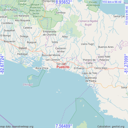
Pueblito GPS coordinates[2]
8° 15' 40.752" North, 81° 58' 26.796" West
| Map corner | latitude | longitude |
|---|---|---|
| Upper-left | 8.95652°, | -82.67724° |
| Center: | 8.26132°, | -81.97411° |
| Lower-right: | 7.56489°, | -81.27099° |
| Map W x H: | 154.7×154.7 km | = 96.1×96.1mi |
| max Lat: | 9.60898° ⇑68.8% North |
| Pueblito: | 8.26132° |
| min Lat: | ⇓31.2% South 7.26534° |
| min Long | Pueblito | max Long |
| -82.91275° | -81.97411° | -77.38965° |
| W 21.7%⇐ | ⇒78.3% E |
Elevation
Elevation of Pueblito is 20 m = 66 ft, and this is 152.1 m = 499 ft below average elevation for this country.
| Max E: |
2103 m = 6900 ft | 82.5% |
| Avg. | 172.1 m = 565 ft | |
| Pueblito | 20 m = 66 ft | |
Min E: |
-1 m = -3 ft | 17.5% |
See also: Panama elevation on elevation.city.
Geographical zone
Pueblito is located in North Torrid zone (between Equator and Tropic of Cancer). Distance of Equator is 918.6 km =570.8 mi to South.| Distance of | km | miles | from Pueblito |
|---|---|---|---|
| North Pole | 9088.5 | 5647.3 | to North |
| Arctic Circle | 6482.6 | 4028.1 | to North |
| Tropic Cancer | 1687.3 | 1048.4 | to North |
| Equator | 918.6 | 570.8 | to South |


Nearby cities:
15 places around Pueblito: (largest is in red/bold)
• Camarón Arriba
13.7 km =8.5 mi,  351°
351°
• El Porvenir
16 km =9.9 mi,  102°
102°
• Hato Corotú
8.2 km =5.1 mi,  2°
2°
• Juay
4 km =2.5 mi,  50°
50°
• Lajas Adentro
10.7 km =6.6 mi, 96°
• Las Lajas
11.7 km =7.3 mi, 100°
• Las Matas
12.6 km =7.8 mi,  70°
70°
• Pueblo Nuevo
14.5 km =9 mi,  287°
287°
• Quebrada de Loro
12 km =7.5 mi,  25°
25°
• Salto Dupí
13.9 km =8.6 mi,  43°
43°
• San Félix
12.2 km =7.6 mi, 74°
• San Juan
2.8 km =1.7 mi,  309°
309°
• San Lorenzo
14.8 km =9.2 mi, 289°
• Santa Cruz
7.4 km =4.6 mi,  115°
115°
• Santa Lucia
16.6 km =10.3 mi, 101°
Sources, notices
• [Note1] Compared only with cities in Panama existing in our database
• [Src1] Map data: © OpenStreetMap contributors (CC-BY-SA)
• [Src2] Other city data from geonames.org with taken over terms of usage.
• [Src3] Geographical zone / Annual Mean Temperature by Robert A. Rohde @ Wikipedia
