Salto Dupí geodata
Salto Dupí (Ngöbe-Buglé) is a seat of a third-order administrative division; located in Panama in America/Panama (GMT-5) time zone. In our database, there are 694 cities with bigger population. Compared to other cities in Panama, 62.5% of cities are located further ↑North; 77.6% of cities are located further →East and 70.4% of cities have lower elevation than Salto Dupí. Note1


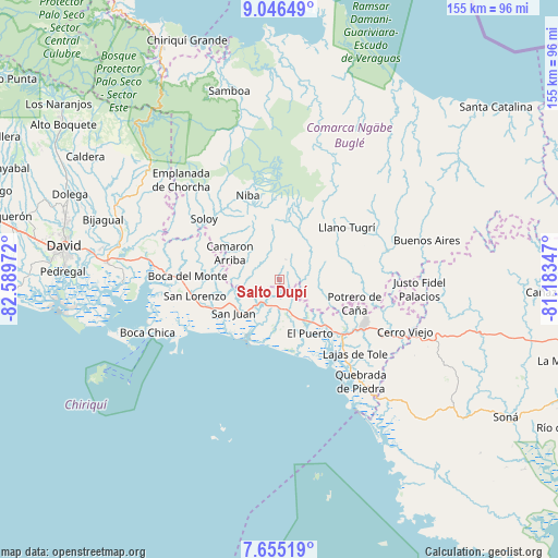
Salto Dupí GPS coordinates[2]
8° 21' 5.256" North, 81° 53' 11.724" West
| Map corner | latitude | longitude |
|---|---|---|
| Upper-left | 9.04649°, | -82.58972° |
| Center: | 8.35146°, | -81.88659° |
| Lower-right: | 7.65519°, | -81.18347° |
| Map W x H: | 154.7×154.7 km | = 96.1×96.1mi |
| max Lat: | 9.60898° ⇑62.5% North |
| Salto Dupí: | 8.35146° |
| min Lat: | ⇓37.5% South 7.26534° |
| min Long | Salto Dupí | max Long |
| -82.91275° | -81.88659° | -77.38965° |
| W 22.4%⇐ | ⇒77.6% E |
Elevation
Elevation of Salto Dupí is 159 m = 522 ft, and this is 13.1 m = 43 ft below average elevation for this country.
| Max E: |
2103 m = 6900 ft | 29.6% |
| Avg. | 172.1 m = 565 ft | |
| Salto Dupí | 159 m = 522 ft | |
Min E: |
-1 m = -3 ft | 70.4% |
See also: Panama elevation on elevation.city.
Geographical zone
Salto Dupí is located in North Torrid zone (between Equator and Tropic of Cancer). Distance of Equator is 928.6 km =577 mi to South.| Distance of | km | miles | from Salto Dupí |
|---|---|---|---|
| North Pole | 9078.5 | 5641.1 | to North |
| Arctic Circle | 6472.6 | 4021.9 | to North |
| Tropic Cancer | 1677.3 | 1042.2 | to North |
| Equator | 928.6 | 577 | to South |


Nearby cities:
15 places around Salto Dupí: (largest is in red/bold)
• Camarón Arriba
12.3 km =7.6 mi,  286°
286°
• Cerro Ceniza
13.3 km =8.3 mi,  94°
94°
• Cerro Iglesias
12.2 km =7.6 mi,  127°
127°
• Hato Corotú
9.4 km =5.8 mi,  258°
258°
• Hato Culantro
13.4 km =8.3 mi,  13°
13°
• Hato Jobo
4.5 km =2.8 mi,  0°
0°
• Hato Juli
4.6 km =2.9 mi, 92°
• Hato Pilón
5.7 km =3.5 mi,  24°
24°
• Juay
10 km =6.2 mi,  221°
221°
• Lajas Adentro
11.3 km =7 mi,  175°
175°
• Las Lajas
12.3 km =7.6 mi,  171°
171°
• Las Matas
6.2 km =3.9 mi,  158°
158°
• Oma
9.3 km =5.8 mi, 90°
• Quebrada de Loro
4.6 km =2.9 mi,  280°
280°
• San Félix
7.1 km =4.4 mi, 162°
Sources, notices
• [Note1] Compared only with cities in Panama existing in our database
• [Src1] Map data: © OpenStreetMap contributors (CC-BY-SA)
• [Src2] Other city data from geonames.org with taken over terms of usage.
• [Src3] Geographical zone / Annual Mean Temperature by Robert A. Rohde @ Wikipedia
