Hato Corotú geodata
Hato Corotú (Ngöbe-Buglé) is a seat of a third-order administrative division; located in Panama in America/Panama (GMT-5) time zone. With population of 303 people, there are 559 cities with bigger population in this country. Compared to other cities in Panama, 64.5% of cities are located further ↑North; 78.2% of cities are located further →East and 70.7% of cities have lower elevation than Hato Corotú. Note1


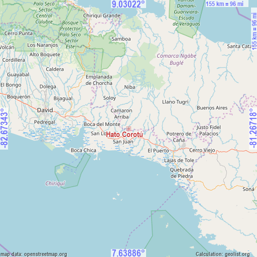
Hato Corotú GPS coordinates[2]
8° 20' 6.576" North, 81° 58' 13.08" West
| Map corner | latitude | longitude |
|---|---|---|
| Upper-left | 9.03022°, | -82.67343° |
| Center: | 8.33516°, | -81.9703° |
| Lower-right: | 7.63886°, | -81.26718° |
| Map W x H: | 154.7×154.7 km | = 96.1×96.1mi |
| max Lat: | 9.60898° ⇑64.5% North |
| Hato Corotú: | 8.33516° |
| min Lat: | ⇓35.5% South 7.26534° |
| min Long | Hato Corotú | max Long |
| -82.91275° | -81.9703° | -77.38965° |
| W 21.8%⇐ | ⇒78.2% E |
Elevation
Elevation of Hato Corotú is 160 m = 525 ft, and this is 12.1 m = 40 ft below average elevation for this country.
| Max E: |
2103 m = 6900 ft | 29.3% |
| Avg. | 172.1 m = 565 ft | |
| Hato Corotú | 160 m = 525 ft | |
Min E: |
-1 m = -3 ft | 70.7% |
See also: Panama elevation on elevation.city.
Geographical zone
Hato Corotú is located in North Torrid zone (between Equator and Tropic of Cancer). Distance of Equator is 926.8 km =575.9 mi to South.| Distance of | km | miles | from Hato Corotú |
|---|---|---|---|
| North Pole | 9080.3 | 5642.2 | to North |
| Arctic Circle | 6474.4 | 4023 | to North |
| Tropic Cancer | 1679.1 | 1043.3 | to North |
| Equator | 926.8 | 575.9 | to South |


Nearby cities:
15 places around Hato Corotú: (largest is in red/bold)
• Camarón Arriba
5.9 km =3.7 mi,  334°
334°
• Hato Jobo
11.2 km =7 mi,  55°
55°
• Hato Juli
13.9 km =8.6 mi,  83°
83°
• Hato Pilón
13.5 km =8.4 mi, 58°
• Juay
6.3 km =3.9 mi,  155°
155°
• Lajas Adentro
13.9 km =8.6 mi,  132°
132°
• Las Matas
12.1 km =7.5 mi,  109°
109°
• Pueblito
8.2 km =5.1 mi,  182°
182°
• Pueblo Nuevo
14.8 km =9.2 mi,  254°
254°
• Quebrada de Loro
5.4 km =3.4 mi, 60°
• Salto Dupí
9.4 km =5.8 mi, 78°
• San Félix
12.4 km =7.7 mi, 113°
• San Juan
6.9 km =4.3 mi,  201°
201°
• San Lorenzo
14.8 km =9.2 mi,  257°
257°
• Santa Cruz
13.1 km =8.1 mi,  151°
151°
Sources, notices
• [Note1] Compared only with cities in Panama existing in our database
• [Src1] Map data: © OpenStreetMap contributors (CC-BY-SA)
• [Src2] Other city data from geonames.org with taken over terms of usage.
• [Src3] Geographical zone / Annual Mean Temperature by Robert A. Rohde @ Wikipedia
