Breñón geodata
Breñón (Chiriquí) is a seat of a third-order administrative division; located in Panama in America/Panama (GMT-5) time zone. With population of 230 people, there are 589 cities with bigger population in this country. Compared to other cities in Panama, 65.7% of cities are located further ↓South; 96.7% of cities are located further →East and 95.1% of cities have lower elevation than Breñón. Note1


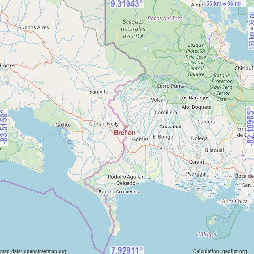
Breñón GPS coordinates[2]
8° 37' 29.676" North, 82° 48' 45.972" West
| Map corner | latitude | longitude |
|---|---|---|
| Upper-left | 9.31943°, | -83.5159° |
| Center: | 8.62491°, | -82.81277° |
| Lower-right: | 7.92911°, | -82.10965° |
| Map W x H: | 154.6×154.6 km | = 96.1×96.1mi |
| max Lat: | 9.60898° ⇑34.3% North |
| Breñón: | 8.62491° |
| min Lat: | ⇓65.7% South 7.26534° |
| min Long | Breñón | max Long |
| -82.91275° | -82.81277° | -77.38965° |
| W 3.3%⇐ | ⇒96.7% E |
Elevation
Elevation of Breñón is 677 m = 2221 ft, and this is 504.9 m = 1656 ft above average elevation for this country.
| Max E: |
2103 m = 6900 ft | 4.9% |
| Breñón | 677 m 2221 ft | |
| Avg. | 172.1 m = 565 ft | |
Min E: |
-1 m = -3 ft | 95.1% |
See also: Panama elevation on elevation.city.
Geographical zone
Breñón is located in North Torrid zone (between Equator and Tropic of Cancer). Distance of Equator is 959 km =595.9 mi to South.| Distance of | km | miles | from Breñón |
|---|---|---|---|
| North Pole | 9048.1 | 5622.2 | to North |
| Arctic Circle | 6442.2 | 4003 | to North |
| Tropic Cancer | 1646.9 | 1023.3 | to North |
| Equator | 959 | 595.9 | to South |


Nearby cities:
15 places around Breñón: (largest is in red/bold)
• Alto Quiel
15 km =9.3 mi,  320°
320°
• Aserrío de Gariché
16 km =9.9 mi,  171°
171°
• Celmira
9.5 km =5.9 mi, 171°
• El Roble
14 km =8.7 mi,  162°
162°
• Gómez
10.6 km =6.6 mi,  132°
132°
• Jacú
15.7 km =9.8 mi,  181°
181°
• La Bonita
5.4 km =3.4 mi,  96°
96°
• Paso Canoas Arriba
6.7 km =4.2 mi,  188°
188°
• Plaza de Caisán
12.5 km =7.8 mi,  356°
356°
• Portón
7.7 km =4.8 mi, 156°
• San Andrés
9.9 km =6.2 mi, 104°
• San Francisco
9.3 km =5.8 mi,  83°
83°
• San Isidro
10.6 km =6.6 mi, 188°
• Santa Cruz
6.2 km =3.9 mi,  71°
71°
• Santa Rosa
14.3 km =8.9 mi, 101°
Sources, notices
• [Note1] Compared only with cities in Panama existing in our database
• [Src1] Map data: © OpenStreetMap contributors (CC-BY-SA)
• [Src2] Other city data from geonames.org with taken over terms of usage.
• [Src3] Geographical zone / Annual Mean Temperature by Robert A. Rohde @ Wikipedia
