Santa Cruz geodata
Santa Cruz (Chiriquí) is a seat of a third-order administrative division; located in Panama in America/Panama (GMT-5) time zone. With population of 274 people, there are 566 cities with bigger population in this country. Compared to other cities in Panama, 67.4% of cities are located further ↓South; 95.2% of cities are located further →East and 94.6% of cities have lower elevation than Santa Cruz. Note1


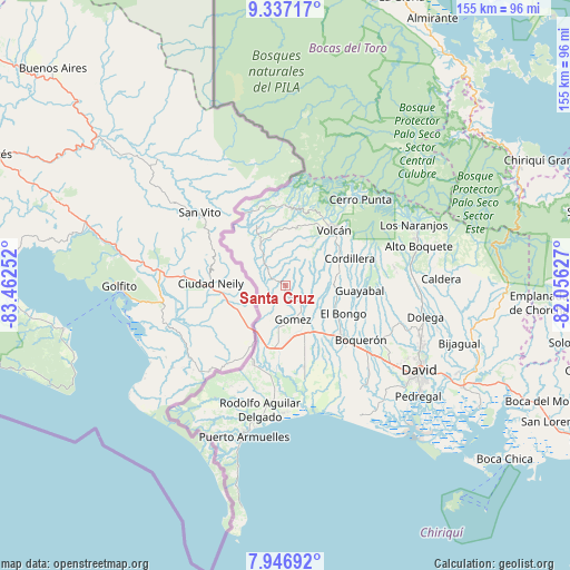
Santa Cruz GPS coordinates[2]
8° 38' 33.684" North, 82° 45' 33.804" West
| Map corner | latitude | longitude |
|---|---|---|
| Upper-left | 9.33717°, | -83.46252° |
| Center: | 8.64269°, | -82.75939° |
| Lower-right: | 7.94692°, | -82.05627° |
| Map W x H: | 154.6×154.6 km | = 96.1×96.1mi |
| max Lat: | 9.60898° ⇑32.6% North |
| Santa Cruz: | 8.64269° |
| min Lat: | ⇓67.4% South 7.26534° |
| min Long | Santa Cruz | max Long |
| -82.91275° | -82.75939° | -77.38965° |
| W 4.8%⇐ | ⇒95.2% E |
Elevation
Elevation of Santa Cruz is 664 m = 2178 ft, and this is 491.9 m = 1614 ft above average elevation for this country.
| Max E: |
2103 m = 6900 ft | 5.4% |
| Santa Cruz | 664 m 2178 ft | |
| Avg. | 172.1 m = 565 ft | |
Min E: |
-1 m = -3 ft | 94.6% |
See also: Panama elevation on elevation.city.
Geographical zone
Santa Cruz is located in North Torrid zone (between Equator and Tropic of Cancer). Distance of Equator is 961 km =597.1 mi to South.| Distance of | km | miles | from Santa Cruz |
|---|---|---|---|
| North Pole | 9046.1 | 5621 | to North |
| Arctic Circle | 6440.2 | 4001.8 | to North |
| Tropic Cancer | 1644.9 | 1022.1 | to North |
| Equator | 961 | 597.1 | to South |


Nearby cities:
15 places around Santa Cruz: (largest is in red/bold)
• Breñón
6.2 km =3.9 mi,  251°
251°
• Celmira
12.2 km =7.6 mi,  201°
201°
• El Roble
15.4 km =9.6 mi,  186°
186°
• El Santo
12.5 km =7.8 mi,  135°
135°
• Gómez
9.3 km =5.8 mi,  167°
167°
• La Bonita
2.7 km =1.7 mi, 190°
• Paso Canoas Arriba
11 km =6.8 mi,  218°
218°
• Plaza de Caisán
12.4 km =7.7 mi,  327°
327°
• Portón
9.5 km =5.9 mi, 197°
• San Andrés
5.8 km =3.6 mi, 140°
• San Francisco
3.5 km =2.2 mi,  106°
106°
• San Isidro
14.5 km =9 mi,  210°
210°
• San Vicente
14.7 km =9.1 mi, 113°
• Santa Rosa
9.5 km =5.9 mi,  120°
120°
• Sioguí Arriba
14.1 km =8.8 mi,  145°
145°
Sources, notices
• [Note1] Compared only with cities in Panama existing in our database
• [Src1] Map data: © OpenStreetMap contributors (CC-BY-SA)
• [Src2] Other city data from geonames.org with taken over terms of usage.
• [Src3] Geographical zone / Annual Mean Temperature by Robert A. Rohde @ Wikipedia
