La Tronosa geodata
La Tronosa (Los Santos) is a seat of a third-order administrative division; located in Panama in America/Panama (GMT-5) time zone. With population of 79 people, there are 671 cities with bigger population in this country. Compared to other cities in Panama, 99.2% of cities are located further ↑North; 50% of cities are located further ←West and 58.2% of cities have lower elevation than La Tronosa. Note1


La Tronosa GPS coordinates[2]
7° 26' 9.924" North, 80° 35' 13.128" West
| Map corner | latitude | longitude |
|---|---|---|
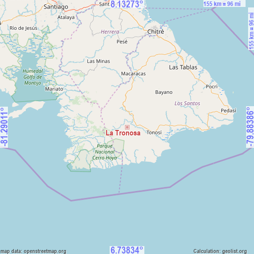
| Upper-left | 8.13273°, | -81.29011° |
| Center: | 7.43609°, | -80.58698° |
| Lower-right: | 6.73834°, | -79.88386° |
| Map W x H: | 155×155 km | = 96.3×96.3mi |
| max Lat: | 9.60898° ⇑99.2% North |
| La Tronosa: | 7.43609° |
| min Lat: | ⇓0.8% South 7.26534° |
| min Long | La Tronosa | max Long |
| -82.91275° | -80.58698° | -77.38965° |
| W 50%⇐ | ⇒50% E |
Elevation
Elevation of La Tronosa is 97 m = 318 ft, and this is 75.1 m = 246 ft below average elevation for this country.
| Max E: |
2103 m = 6900 ft | 41.8% |
| Avg. | 172.1 m = 565 ft | |
| La Tronosa | 97 m = 318 ft | |
Min E: |
-1 m = -3 ft | 58.2% |
See also: Panama elevation on elevation.city.
Geographical zone
La Tronosa is located in North Torrid zone (between Equator and Tropic of Cancer). Distance of Equator is 826.8 km =513.7 mi to South.| Distance of | km | miles | from La Tronosa |
|---|---|---|---|
| North Pole | 9180.2 | 5704.3 | to North |
| Arctic Circle | 6574.4 | 4085.1 | to North |
| Tropic Cancer | 1779.1 | 1105.5 | to North |
| Equator | 826.8 | 513.7 | to South |


Nearby cities:
15 places around La Tronosa: (largest is in red/bold)
• Altos de Güera
11.1 km =6.9 mi,  340°
340°
• Ave María
19.2 km =11.9 mi,  130°
130°
• Bajos de Güera
12.7 km =7.9 mi, 340°
• Cambutal
21.7 km =13.5 mi,  150°
150°
• El Bebedero
14.7 km =9.1 mi,  101°
101°
• El Cacao
19.6 km =12.2 mi,  86°
86°
• El Cedro
28.9 km =18 mi, 343°
• El Cortezo
5.2 km =3.2 mi,  258°
258°
• Flores
20.5 km =12.7 mi,  75°
75°
• La Mesa
24.8 km =15.4 mi,  352°
352°
• Las Palmas
29.2 km =18.1 mi,  19°
19°
• Llano de Piedra
25 km =15.5 mi,  5°
5°
• Mogollón
26.9 km =16.7 mi,  31°
31°
• Pitaloza Arriba
24.6 km =15.3 mi, 338°
• Tonosí
16.3 km =10.1 mi, 101°
Sources, notices
• [Note1] Compared only with cities in Panama existing in our database
• [Src1] Map data: © OpenStreetMap contributors (CC-BY-SA)
• [Src2] Other city data from geonames.org with taken over terms of usage.
• [Src3] Geographical zone / Annual Mean Temperature by Robert A. Rohde @ Wikipedia
