Llano de Piedra geodata
Llano de Piedra (Los Santos) is a seat of a third-order administrative division; located in Panama in America/Panama (GMT-5) time zone. With population of 1,054 people, there are 239 cities with bigger population in this country. Compared to other cities in Panama, 95.6% of cities are located further ↑North; 50.8% of cities are located further ←West and 69.6% of cities have lower elevation than Llano de Piedra. Note1


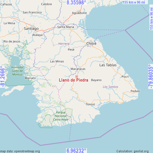
Llano de Piedra GPS coordinates[2]
7° 39' 34.992" North, 80° 33' 48.492" West
| Map corner | latitude | longitude |
|---|---|---|
| Upper-left | 8.35598°, | -81.2666° |
| Center: | 7.65972°, | -80.56347° |
| Lower-right: | 6.96232°, | -79.86035° |
| Map W x H: | 155×155 km | = 96.3×96.3mi |
| max Lat: | 9.60898° ⇑95.6% North |
| Llano de Piedra: | 7.65972° |
| min Lat: | ⇓4.4% South 7.26534° |
| min Long | Llano de Piedra | max Long |
| -82.91275° | -80.56347° | -77.38965° |
| W 50.8%⇐ | ⇒49.2% E |
Elevation
Elevation of Llano de Piedra is 155 m = 509 ft, and this is 17.1 m = 56 ft below average elevation for this country.
| Max E: |
2103 m = 6900 ft | 30.4% |
| Avg. | 172.1 m = 565 ft | |
| Llano de Piedra | 155 m = 509 ft | |
Min E: |
-1 m = -3 ft | 69.6% |
See also: Panama elevation on elevation.city.
Geographical zone
Llano de Piedra is located in North Torrid zone (between Equator and Tropic of Cancer). Distance of Equator is 851.7 km =529.2 mi to South.| Distance of | km | miles | from Llano de Piedra |
|---|---|---|---|
| North Pole | 9155.4 | 5688.9 | to North |
| Arctic Circle | 6549.5 | 4069.7 | to North |
| Tropic Cancer | 1754.2 | 1090 | to North |
| Equator | 851.7 | 529.2 | to South |


Nearby cities:
15 places around Llano de Piedra: (largest is in red/bold)
• Bahía Honda
13.1 km =8.1 mi,  67°
67°
• Bajos de Güera
14.6 km =9.1 mi,  207°
207°
• Cedro Arriba
14 km =8.7 mi,  15°
15°
• Chupá
15.6 km =9.7 mi,  355°
355°
• El Calabacito
7.5 km =4.7 mi,  330°
330°
• El Capurí
11.5 km =7.1 mi,  309°
309°
• El Cedro
10.9 km =6.8 mi,  285°
285°
• El Espino Amarillo
13.8 km =8.6 mi,  82°
82°
• La Arena
10.6 km =6.6 mi,  342°
342°
• La Mesa
6 km =3.7 mi,  266°
266°
• Las Palmas
7.7 km =4.8 mi, 70°
• Los Cerros de Paja
13.7 km =8.5 mi,  298°
298°
• Macaracas
8.1 km =5 mi,  7°
7°
• Mogollón
11.6 km =7.2 mi,  99°
99°
• Pitaloza Arriba
11.7 km =7.3 mi,  260°
260°
Sources, notices
• [Note1] Compared only with cities in Panama existing in our database
• [Src1] Map data: © OpenStreetMap contributors (CC-BY-SA)
• [Src2] Other city data from geonames.org with taken over terms of usage.
• [Src3] Geographical zone / Annual Mean Temperature by Robert A. Rohde @ Wikipedia
