El Cacao geodata
El Cacao (Los Santos) is a seat of a third-order administrative division; located in Panama in America/Panama (GMT-5) time zone. With population of 261 people, there are 568 cities with bigger population in this country. Compared to other cities in Panama, 99% of cities are located further ↑North; 57.1% of cities are located further ←West and 87.9% of cities have higher elevation than El Cacao. Note1


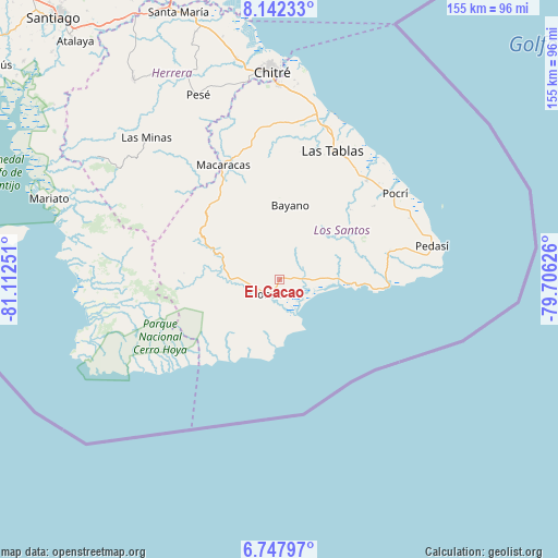
El Cacao GPS coordinates[2]
7° 26' 44.52" North, 80° 24' 33.768" West
| Map corner | latitude | longitude |
|---|---|---|
| Upper-left | 8.14233°, | -81.11251° |
| Center: | 7.4457°, | -80.40938° |
| Lower-right: | 6.74797°, | -79.70626° |
| Map W x H: | 155×155 km | = 96.3×96.3mi |
| max Lat: | 9.60898° ⇑99% North |
| El Cacao: | 7.4457° |
| min Lat: | ⇓1% South 7.26534° |
| min Long | El Cacao | max Long |
| -82.91275° | -80.40938° | -77.38965° |
| W 57.1%⇐ | ⇒42.9% E |
Elevation
Elevation of El Cacao is 14 m = 46 ft, and this is 158.1 m = 519 ft below average elevation for this country.
| Max E: |
2103 m = 6900 ft | 87.9% |
| Avg. | 172.1 m = 565 ft | |
| El Cacao | 14 m = 46 ft | |
Min E: |
-1 m = -3 ft | 12.1% |
See also: Panama elevation on elevation.city.
Geographical zone
El Cacao is located in North Torrid zone (between Equator and Tropic of Cancer). Distance of Equator is 827.9 km =514.4 mi to South.| Distance of | km | miles | from El Cacao |
|---|---|---|---|
| North Pole | 9179.2 | 5703.7 | to North |
| Arctic Circle | 6573.3 | 4084.5 | to North |
| Tropic Cancer | 1778 | 1104.8 | to North |
| Equator | 827.9 | 514.4 | to South |


Nearby cities:
15 places around El Cacao: (largest is in red/bold)
• Ave María
14.3 km =8.9 mi,  199°
199°
• Bajo Corral
24.1 km =15 mi,  42°
42°
• Bayano
20.7 km =12.9 mi,  8°
8°
• Cambutal
22 km =13.7 mi, 204°
• Cañas
15.9 km =9.9 mi,  89°
89°
• El Bebedero
6.5 km =4 mi,  232°
232°
• Flores
4 km =2.5 mi,  3°
3°
• La Miel
15.6 km =9.7 mi, 35°
• La Tronosa
19.6 km =12.2 mi,  266°
266°
• Mogollón
22.6 km =14 mi,  345°
345°
• Nuario
13.1 km =8.1 mi, 43°
• Oria Arriba
23.4 km =14.5 mi,  73°
73°
• Tonosí
5.6 km =3.5 mi,  219°
219°
• Valle Rico
20.4 km =12.7 mi,  18°
18°
• Vallerriquito
21.9 km =13.6 mi,  26°
26°
Sources, notices
• [Note1] Compared only with cities in Panama existing in our database
• [Src1] Map data: © OpenStreetMap contributors (CC-BY-SA)
• [Src2] Other city data from geonames.org with taken over terms of usage.
• [Src3] Geographical zone / Annual Mean Temperature by Robert A. Rohde @ Wikipedia
