Las Palmas geodata
Las Palmas (Los Santos) is a seat of a third-order administrative division; located in Panama in America/Panama (GMT-5) time zone. With population of 13 people, there are 692 cities with bigger population in this country. Compared to other cities in Panama, 95% of cities are located further ↑North; 53.4% of cities are located further ←West and 70.2% of cities have lower elevation than Las Palmas. Note1


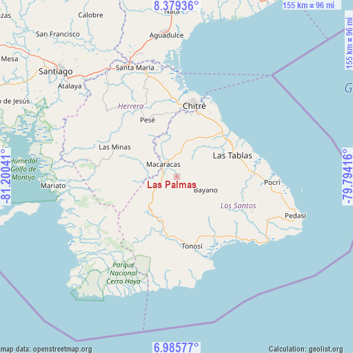
Las Palmas GPS coordinates[2]
7° 40' 59.304" North, 80° 29' 50.208" West
| Map corner | latitude | longitude |
|---|---|---|
| Upper-left | 8.37936°, | -81.20041° |
| Center: | 7.68314°, | -80.49728° |
| Lower-right: | 6.98577°, | -79.79416° |
| Map W x H: | 155×155 km | = 96.3×96.3mi |
| max Lat: | 9.60898° ⇑95% North |
| Las Palmas: | 7.68314° |
| min Lat: | ⇓5% South 7.26534° |
| min Long | Las Palmas | max Long |
| -82.91275° | -80.49728° | -77.38965° |
| W 53.4%⇐ | ⇒46.6% E |
Elevation
Elevation of Las Palmas is 157 m = 515 ft, and this is 15.1 m = 50 ft below average elevation for this country.
| Max E: |
2103 m = 6900 ft | 29.8% |
| Avg. | 172.1 m = 565 ft | |
| Las Palmas | 157 m = 515 ft | |
Min E: |
-1 m = -3 ft | 70.2% |
See also: Panama elevation on elevation.city.
Geographical zone
Las Palmas is located in North Torrid zone (between Equator and Tropic of Cancer). Distance of Equator is 854.3 km =530.8 mi to South.| Distance of | km | miles | from Las Palmas |
|---|---|---|---|
| North Pole | 9152.8 | 5687.3 | to North |
| Arctic Circle | 6546.9 | 4068.1 | to North |
| Tropic Cancer | 1751.6 | 1088.4 | to North |
| Equator | 854.3 | 530.8 | to South |


Nearby cities:
15 places around Las Palmas: (largest is in red/bold)
• Bahía Honda
5.4 km =3.4 mi,  63°
63°
• Bayano
14 km =8.7 mi,  114°
114°
• Cedro Arriba
11.5 km =7.1 mi,  341°
341°
• El Calabacito
11.7 km =7.3 mi,  289°
289°
• El Espino Amarillo
6.5 km =4 mi,  96°
96°
• El Guásimo
14.2 km =8.8 mi,  345°
345°
• El Macano
10.4 km =6.5 mi,  88°
88°
• La Arena
12.9 km =8 mi,  305°
305°
• La Mesa
13.6 km =8.5 mi,  257°
257°
• La Palma
13.1 km =8.1 mi,  73°
73°
• Las Guabas
14.6 km =9.1 mi,  358°
358°
• Llano de Piedra
7.7 km =4.8 mi,  250°
250°
• Macaracas
8.2 km =5.1 mi, 310°
• Mogollón
6.1 km =3.8 mi,  137°
137°
• Villa Lourdes
14.6 km =9.1 mi,  11°
11°
Sources, notices
• [Note1] Compared only with cities in Panama existing in our database
• [Src1] Map data: © OpenStreetMap contributors (CC-BY-SA)
• [Src2] Other city data from geonames.org with taken over terms of usage.
• [Src3] Geographical zone / Annual Mean Temperature by Robert A. Rohde @ Wikipedia
