La Palma geodata
La Palma (Los Santos) is a populated place; located in Panama in America/Panama (GMT-5) time zone. With population of 1,283 people, there are 192 cities with bigger population in this country. Compared to other cities in Panama, 93.7% of cities are located further ↑North; 58.3% of cities are located further ←West and 74.2% of cities have lower elevation than La Palma. Note1


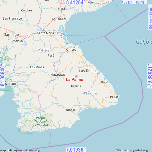
La Palma GPS coordinates[2]
7° 43' 0.012" North, 80° 22' 59.988" West
| Map corner | latitude | longitude |
|---|---|---|
| Upper-left | 8.41284°, | -81.08646° |
| Center: | 7.71667°, | -80.38333° |
| Lower-right: | 7.01936°, | -79.68021° |
| Map W x H: | 154.9×154.9 km | = 96.3×96.3mi |
| max Lat: | 9.60898° ⇑93.7% North |
| La Palma: | 7.71667° |
| min Lat: | ⇓6.3% South 7.26534° |
| min Long | La Palma | max Long |
| -82.91275° | -80.38333° | -77.38965° |
| W 58.3%⇐ | ⇒41.7% E |
Elevation
Elevation of La Palma is 193 m = 633 ft, and this is 20.9 m = 69 ft above average elevation for this country.
| Max E: |
2103 m = 6900 ft | 25.8% |
| La Palma | 193 m 633 ft | |
| Avg. | 172.1 m = 565 ft | |
Min E: |
-1 m = -3 ft | 74.2% |
See also: Panama elevation on elevation.city.
Geographical zone
La Palma is located in North Torrid zone (between Equator and Tropic of Cancer). Distance of Equator is 858 km =533.1 mi to South.| Distance of | km | miles | from La Palma |
|---|---|---|---|
| North Pole | 9149 | 5684.9 | to North |
| Arctic Circle | 6543.2 | 4065.8 | to North |
| Tropic Cancer | 1747.9 | 1086.1 | to North |
| Equator | 858 | 533.1 | to South |


Nearby cities:
15 places around La Palma: (largest is in red/bold)
• Bahía Honda
7.8 km =4.8 mi,  260°
260°
• Bayano
9.6 km =6 mi,  179°
179°
• El Carate
9.7 km =6 mi,  80°
80°
• El Espino Amarillo
7.6 km =4.7 mi,  233°
233°
• El Hato
8.5 km =5.3 mi,  0°
0°
• El Macano
4.2 km =2.6 mi,  211°
211°
• El Muñoz
8.2 km =5.1 mi,  123°
123°
• El Pedregoso
6.7 km =4.2 mi,  114°
114°
• Guararé Arriba
9.6 km =6 mi,  15°
15°
• La Tiza
10.7 km =6.6 mi,  69°
69°
• Las Trancas
2.2 km =1.4 mi,  28°
28°
• Llano Abajo
8.3 km =5.2 mi,  338°
338°
• Palmira
6.6 km =4.1 mi,  154°
154°
• Perales
9.1 km =5.7 mi,  44°
44°
• Río Hondo
2.7 km =1.7 mi,  101°
101°
Sources, notices
• [Note1] Compared only with cities in Panama existing in our database
• [Src1] Map data: © OpenStreetMap contributors (CC-BY-SA)
• [Src2] Other city data from geonames.org with taken over terms of usage.
• [Src3] Geographical zone / Annual Mean Temperature by Robert A. Rohde @ Wikipedia
