El Muñoz geodata
El Muñoz (Los Santos) is a seat of a third-order administrative division; located in Panama in America/Panama (GMT-5) time zone. With population of 161 people, there are 625 cities with bigger population in this country. Compared to other cities in Panama, 95.2% of cities are located further ↑North; 61.3% of cities are located further ←West and 75.1% of cities have lower elevation than El Muñoz. Note1


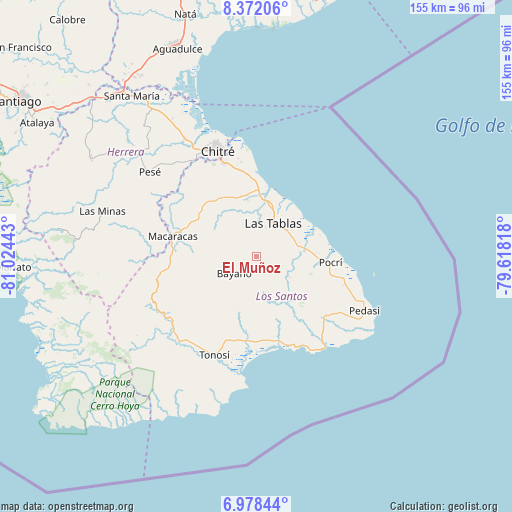
El Muñoz GPS coordinates[2]
7° 40' 32.952" North, 80° 19' 16.68" West
| Map corner | latitude | longitude |
|---|---|---|
| Upper-left | 8.37206°, | -81.02443° |
| Center: | 7.67582°, | -80.3213° |
| Lower-right: | 6.97844°, | -79.61818° |
| Map W x H: | 155×155 km | = 96.3×96.3mi |
| max Lat: | 9.60898° ⇑95.2% North |
| El Muñoz: | 7.67582° |
| min Lat: | ⇓4.8% South 7.26534° |
| min Long | El Muñoz | max Long |
| -82.91275° | -80.3213° | -77.38965° |
| W 61.3%⇐ | ⇒38.7% E |
Elevation
Elevation of El Muñoz is 202 m = 663 ft, and this is 29.9 m = 98 ft above average elevation for this country.
| Max E: |
2103 m = 6900 ft | 24.9% |
| El Muñoz | 202 m 663 ft | |
| Avg. | 172.1 m = 565 ft | |
Min E: |
-1 m = -3 ft | 75.1% |
See also: Panama elevation on elevation.city.
Geographical zone
El Muñoz is located in North Torrid zone (between Equator and Tropic of Cancer). Distance of Equator is 853.5 km =530.3 mi to South.| Distance of | km | miles | from El Muñoz |
|---|---|---|---|
| North Pole | 9153.6 | 5687.8 | to North |
| Arctic Circle | 6547.7 | 4068.6 | to North |
| Tropic Cancer | 1752.4 | 1088.9 | to North |
| Equator | 853.5 | 530.3 | to South |


Nearby cities:
15 places around El Muñoz: (largest is in red/bold)
• Bayano
8.4 km =5.2 mi,  232°
232°
• El Carate
6.7 km =4.2 mi,  23°
23°
• El Cocal
8.2 km =5.1 mi,  33°
33°
• El Macano
9.1 km =5.7 mi,  276°
276°
• El Pedregoso
1.9 km =1.2 mi,  337°
337°
• La Laja
9.7 km =6 mi,  50°
50°
• La Palma
8.2 km =5.1 mi,  303°
303°
• La Tiza
9 km =5.6 mi, 20°
• Las Trancas
8.7 km =5.4 mi,  318°
318°
• Palmira
4.2 km =2.6 mi,  250°
250°
• Peña Blanca
6.4 km =4 mi,  40°
40°
• Río Hondo
5.8 km =3.6 mi,  313°
313°
• San José
8.5 km =5.3 mi,  91°
91°
• Valle Rico
7 km =4.3 mi,  207°
207°
• Vallerriquito
6 km =3.7 mi,  178°
178°
Sources, notices
• [Note1] Compared only with cities in Panama existing in our database
• [Src1] Map data: © OpenStreetMap contributors (CC-BY-SA)
• [Src2] Other city data from geonames.org with taken over terms of usage.
• [Src3] Geographical zone / Annual Mean Temperature by Robert A. Rohde @ Wikipedia
