Bahía Honda geodata
Bahía Honda (Los Santos) is a seat of a third-order administrative division; located in Panama in America/Panama (GMT-5) time zone. With population of 131 people, there are 639 cities with bigger population in this country. Compared to other cities in Panama, 94.2% of cities are located further ↑North; 54.7% of cities are located further ←West and 81.5% of cities have lower elevation than Bahía Honda. Note1


Bahía Honda GPS coordinates[2]
7° 42' 18.612" North, 80° 27' 12.312" West
| Map corner | latitude | longitude |
|---|---|---|
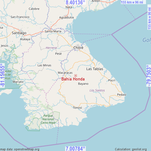
| Upper-left | 8.40136°, | -81.15655° |
| Center: | 7.70517°, | -80.45342° |
| Lower-right: | 7.00784°, | -79.7503° |
| Map W x H: | 154.9×154.9 km | = 96.3×96.3mi |
| max Lat: | 9.60898° ⇑94.2% North |
| Bahía Honda: | 7.70517° |
| min Lat: | ⇓5.8% South 7.26534° |
| min Long | Bahía Honda | max Long |
| -82.91275° | -80.45342° | -77.38965° |
| W 54.7%⇐ | ⇒45.3% E |
Elevation
Elevation of Bahía Honda is 284 m = 932 ft, and this is 111.9 m = 367 ft above average elevation for this country.
| Max E: |
2103 m = 6900 ft | 18.5% |
| Bahía Honda | 284 m 932 ft | |
| Avg. | 172.1 m = 565 ft | |
Min E: |
-1 m = -3 ft | 81.5% |
See also: Panama elevation on elevation.city.
Geographical zone
Bahía Honda is located in North Torrid zone (between Equator and Tropic of Cancer). Distance of Equator is 856.7 km =532.3 mi to South.| Distance of | km | miles | from Bahía Honda |
|---|---|---|---|
| North Pole | 9150.3 | 5685.7 | to North |
| Arctic Circle | 6544.4 | 4066.5 | to North |
| Tropic Cancer | 1749.2 | 1086.9 | to North |
| Equator | 856.7 | 532.3 | to South |


Nearby cities:
15 places around Bahía Honda: (largest is in red/bold)
• Bayano
11.5 km =7.1 mi,  136°
136°
• Cedro Arriba
12 km =7.5 mi,  314°
314°
• El Espino Amarillo
3.6 km =2.2 mi,  153°
153°
• El Hato
12.5 km =7.8 mi,  38°
38°
• El Macano
6 km =3.7 mi,  112°
112°
• La Palma
7.8 km =4.8 mi,  80°
80°
• Las Palmas
5.4 km =3.4 mi,  243°
243°
• Las Trancas
9.3 km =5.8 mi,  69°
69°
• Llano Abajo
10.1 km =6.3 mi,  27°
27°
• Llano de Piedra
13.1 km =8.1 mi,  247°
247°
• Macaracas
11.4 km =7.1 mi,  284°
284°
• Mogollón
7 km =4.3 mi,  185°
185°
• Palmira
11.6 km =7.2 mi, 113°
• Río Hondo
10.4 km =6.5 mi,  85°
85°
• Villa Lourdes
12 km =7.5 mi,  351°
351°
Sources, notices
• [Note1] Compared only with cities in Panama existing in our database
• [Src1] Map data: © OpenStreetMap contributors (CC-BY-SA)
• [Src2] Other city data from geonames.org with taken over terms of usage.
• [Src3] Geographical zone / Annual Mean Temperature by Robert A. Rohde @ Wikipedia
