Llano Abajo geodata
Llano Abajo (Los Santos) is a seat of a third-order administrative division; located in Panama in America/Panama (GMT-5) time zone. With population of 304 people, there are 557 cities with bigger population in this country. Compared to other cities in Panama, 90.6% of cities are located further ↑North; 56.9% of cities are located further ←West and 53.3% of cities have higher elevation than Llano Abajo. Note1


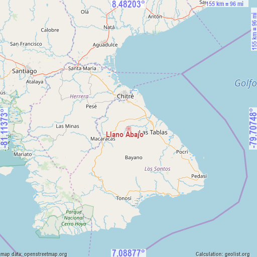
Llano Abajo GPS coordinates[2]
7° 47' 9.528" North, 80° 24' 38.16" West
| Map corner | latitude | longitude |
|---|---|---|
| Upper-left | 8.48203°, | -81.11373° |
| Center: | 7.78598°, | -80.4106° |
| Lower-right: | 7.08877°, | -79.70748° |
| Map W x H: | 154.9×154.9 km | = 96.3×96.3mi |
| max Lat: | 9.60898° ⇑90.6% North |
| Llano Abajo: | 7.78598° |
| min Lat: | ⇓9.4% South 7.26534° |
| min Long | Llano Abajo | max Long |
| -82.91275° | -80.4106° | -77.38965° |
| W 56.9%⇐ | ⇒43.1% E |
Elevation
Elevation of Llano Abajo is 65 m = 213 ft, and this is 107.1 m = 351 ft below average elevation for this country.
| Max E: |
2103 m = 6900 ft | 53.3% |
| Avg. | 172.1 m = 565 ft | |
| Llano Abajo | 65 m = 213 ft | |
Min E: |
-1 m = -3 ft | 46.7% |
See also: Panama elevation on elevation.city.
Geographical zone
Llano Abajo is located in North Torrid zone (between Equator and Tropic of Cancer). Distance of Equator is 865.7 km =537.9 mi to South.| Distance of | km | miles | from Llano Abajo |
|---|---|---|---|
| North Pole | 9141.3 | 5680.1 | to North |
| Arctic Circle | 6535.5 | 4061 | to North |
| Tropic Cancer | 1740.2 | 1081.3 | to North |
| Equator | 865.7 | 537.9 | to South |


Nearby cities:
15 places around Llano Abajo: (largest is in red/bold)
• Agua Buena
5.7 km =3.5 mi,  18°
18°
• Bahía Honda
10.1 km =6.3 mi,  207°
207°
• El Hato
3.2 km =2 mi,  75°
75°
• El Macano
11.3 km =7 mi,  175°
175°
• Guararé Arriba
5.8 km =3.6 mi,  74°
74°
• La Espigadilla
11.1 km =6.9 mi,  11°
11°
• La Palma
8.3 km =5.2 mi,  158°
158°
• Las Cruces
4.6 km =2.9 mi,  332°
332°
• Las Guabas
10.5 km =6.5 mi,  287°
287°
• Las Trancas
7.1 km =4.4 mi,  144°
144°
• Perales
9.5 km =5.9 mi,  97°
97°
• Río Hondo
10 km =6.2 mi,  145°
145°
• Sabana Grande
7.5 km =4.7 mi,  42°
42°
• Tres Quebradas
6 km =3.7 mi,  3°
3°
• Villa Lourdes
7.2 km =4.5 mi, 293°
Sources, notices
• [Note1] Compared only with cities in Panama existing in our database
• [Src1] Map data: © OpenStreetMap contributors (CC-BY-SA)
• [Src2] Other city data from geonames.org with taken over terms of usage.
• [Src3] Geographical zone / Annual Mean Temperature by Robert A. Rohde @ Wikipedia
