Bayano geodata
Bayano (Los Santos) is a seat of a third-order administrative division; located in Panama in America/Panama (GMT-5) time zone. With population of 224 people, there are 593 cities with bigger population in this country. Compared to other cities in Panama, 96.5% of cities are located further ↑North; 58.6% of cities are located further ←West and 79.2% of cities have lower elevation than Bayano. Note1


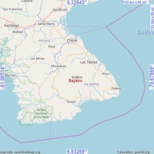
Bayano GPS coordinates[2]
7° 37' 48.504" North, 80° 22' 55.236" West
| Map corner | latitude | longitude |
|---|---|---|
| Upper-left | 8.32645°, | -81.08514° |
| Center: | 7.63014°, | -80.38201° |
| Lower-right: | 6.93269°, | -79.67889° |
| Map W x H: | 155×155 km | = 96.3×96.3mi |
| max Lat: | 9.60898° ⇑96.5% North |
| Bayano: | 7.63014° |
| min Lat: | ⇓3.5% South 7.26534° |
| min Long | Bayano | max Long |
| -82.91275° | -80.38201° | -77.38965° |
| W 58.6%⇐ | ⇒41.4% E |
Elevation
Elevation of Bayano is 254 m = 833 ft, and this is 81.9 m = 269 ft above average elevation for this country.
| Max E: |
2103 m = 6900 ft | 20.8% |
| Bayano | 254 m 833 ft | |
| Avg. | 172.1 m = 565 ft | |
Min E: |
-1 m = -3 ft | 79.2% |
See also: Panama elevation on elevation.city.
Geographical zone
Bayano is located in North Torrid zone (between Equator and Tropic of Cancer). Distance of Equator is 848.4 km =527.2 mi to South.| Distance of | km | miles | from Bayano |
|---|---|---|---|
| North Pole | 9158.7 | 5691 | to North |
| Arctic Circle | 6552.8 | 4071.7 | to North |
| Tropic Cancer | 1757.5 | 1092.1 | to North |
| Equator | 848.4 | 527.2 | to South |


Nearby cities:
15 places around Bayano: (largest is in red/bold)
• Bahía Honda
11.5 km =7.1 mi,  316°
316°
• Bajo Corral
13.7 km =8.5 mi,  101°
101°
• El Espino Amarillo
8.1 km =5 mi,  309°
309°
• El Macano
6.5 km =4 mi,  339°
339°
• El Muñoz
8.4 km =5.2 mi,  52°
52°
• El Pedregoso
9.1 km =5.7 mi,  41°
41°
• La Miel
9.8 km =6.1 mi,  142°
142°
• La Palma
9.6 km =6 mi,  359°
359°
• Las Trancas
11.6 km =7.2 mi,  4°
4°
• Mogollón
8.7 km =5.4 mi,  279°
279°
• Nuario
12.6 km =7.8 mi,  151°
151°
• Palmira
4.6 km =2.9 mi, 36°
• Río Hondo
9.4 km =5.8 mi,  15°
15°
• Valle Rico
3.6 km =2.2 mi,  107°
107°
• Vallerriquito
6.9 km =4.3 mi, 97°
Sources, notices
• [Note1] Compared only with cities in Panama existing in our database
• [Src1] Map data: © OpenStreetMap contributors (CC-BY-SA)
• [Src2] Other city data from geonames.org with taken over terms of usage.
• [Src3] Geographical zone / Annual Mean Temperature by Robert A. Rohde @ Wikipedia
