La Loma geodata
La Loma (Veraguas) is a seat of a third-order administrative division; located in Panama in America/Panama (GMT-5) time zone. With population of 111 people, there are 651 cities with bigger population in this country. Compared to other cities in Panama, 99.1% of cities are located further ↑North; 59.3% of cities are located further →East and 96.3% of cities have higher elevation than La Loma. Note1


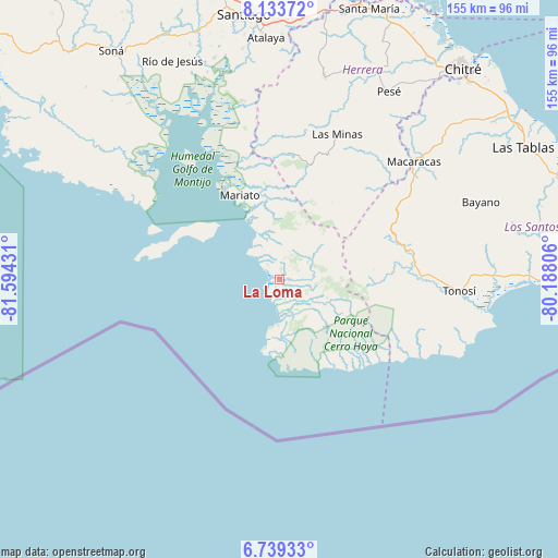
La Loma GPS coordinates[2]
7° 26' 13.488" North, 80° 53' 28.248" West
| Map corner | latitude | longitude |
|---|---|---|
| Upper-left | 8.13372°, | -81.59431° |
| Center: | 7.43708°, | -80.89118° |
| Lower-right: | 6.73933°, | -80.18806° |
| Map W x H: | 155×155 km | = 96.3×96.3mi |
| max Lat: | 9.60898° ⇑99.1% North |
| La Loma: | 7.43708° |
| min Lat: | ⇓0.9% South 7.26534° |
| min Long | La Loma | max Long |
| -82.91275° | -80.89118° | -77.38965° |
| W 40.7%⇐ | ⇒59.3% E |
Elevation
Elevation of La Loma is 6 m = 20 ft, and this is 166.1 m = 545 ft below average elevation for this country.
| Max E: |
2103 m = 6900 ft | 96.3% |
| Avg. | 172.1 m = 565 ft | |
| La Loma | 6 m = 20 ft | |
Min E: |
-1 m = -3 ft | 3.7% |
See also: Panama elevation on elevation.city.
Geographical zone
La Loma is located in North Torrid zone (between Equator and Tropic of Cancer). Distance of Equator is 826.9 km =513.8 mi to South.| Distance of | km | miles | from La Loma |
|---|---|---|---|
| North Pole | 9180.1 | 5704.2 | to North |
| Arctic Circle | 6574.2 | 4085 | to North |
| Tropic Cancer | 1779 | 1105.4 | to North |
| Equator | 826.9 | 513.8 | to South |


Nearby cities:
15 places around La Loma: (largest is in red/bold)
• Altos de Güera
31.5 km =19.6 mi,  70°
70°
• Arenas
8.2 km =5.1 mi,  157°
157°
• Bajos de Güera
31.6 km =19.6 mi, 68°
• El Capurí
42.1 km =26.2 mi,  40°
40°
• El Cedro
37.6 km =23.4 mi, 42°
• El Cortezo
28.5 km =17.7 mi,  92°
92°
• El Toro
35 km =21.7 mi,  3°
3°
• La Mesa
38.8 km =24.1 mi,  50°
50°
• La Punta
35.7 km =22.2 mi,  291°
291°
• La Tronosa
33.5 km =20.8 mi, 90°
• Leones Arriba
36.9 km =22.9 mi,  7°
7°
• Los Cerros de Paja
39.5 km =24.5 mi, 37°
• Pitaloza Arriba
33.6 km =20.9 mi, 47°
• Quebrada del Rosario
34.7 km =21.6 mi,  28°
28°
• Tebario
32.2 km =20 mi,  342°
342°
Sources, notices
• [Note1] Compared only with cities in Panama existing in our database
• [Src1] Map data: © OpenStreetMap contributors (CC-BY-SA)
• [Src2] Other city data from geonames.org with taken over terms of usage.
• [Src3] Geographical zone / Annual Mean Temperature by Robert A. Rohde @ Wikipedia
