El Capurí geodata
El Capurí (Herrera) is a seat of a third-order administrative division; located in Panama in America/Panama (GMT-5) time zone. With population of 124 people, there are 642 cities with bigger population in this country. Compared to other cities in Panama, 93.1% of cities are located further ↑North; 53.1% of cities are located further →East and 80.4% of cities have lower elevation than El Capurí. Note1


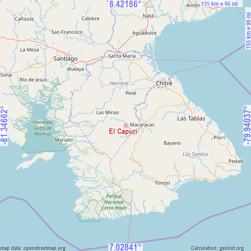
El Capurí GPS coordinates[2]
7° 43' 32.556" North, 80° 38' 36.564" West
| Map corner | latitude | longitude |
|---|---|---|
| Upper-left | 8.42186°, | -81.34662° |
| Center: | 7.72571°, | -80.64349° |
| Lower-right: | 7.02841°, | -79.94037° |
| Map W x H: | 154.9×154.9 km | = 96.3×96.3mi |
| max Lat: | 9.60898° ⇑93.1% North |
| El Capurí: | 7.72571° |
| min Lat: | ⇓6.9% South 7.26534° |
| min Long | El Capurí | max Long |
| -82.91275° | -80.64349° | -77.38965° |
| W 46.9%⇐ | ⇒53.1% E |
Elevation
Elevation of El Capurí is 268 m = 879 ft, and this is 95.9 m = 315 ft above average elevation for this country.
| Max E: |
2103 m = 6900 ft | 19.6% |
| El Capurí | 268 m 879 ft | |
| Avg. | 172.1 m = 565 ft | |
Min E: |
-1 m = -3 ft | 80.4% |
See also: Panama elevation on elevation.city.
Geographical zone
El Capurí is located in North Torrid zone (between Equator and Tropic of Cancer). Distance of Equator is 859 km =533.8 mi to South.| Distance of | km | miles | from El Capurí |
|---|---|---|---|
| North Pole | 9148 | 5684.3 | to North |
| Arctic Circle | 6542.2 | 4065.1 | to North |
| Tropic Cancer | 1746.9 | 1085.5 | to North |
| Equator | 859 | 533.8 | to South |


Nearby cities:
15 places around El Capurí: (largest is in red/bold)
• Cedro Arriba
13.9 km =8.6 mi,  63°
63°
• Chupá
11.2 km =7 mi,  42°
42°
• El Calabacito
5.1 km =3.2 mi,  99°
99°
• El Cedro
4.8 km =3 mi,  201°
201°
• La Arena
6.2 km =3.9 mi, 63°
• La Mesa
8.2 km =5.1 mi,  159°
159°
• Las Minas
13.7 km =8.5 mi,  304°
304°
• Llano de Piedra
11.5 km =7.1 mi,  129°
129°
• Los Cerritos
8.8 km =5.5 mi,  24°
24°
• Los Cerros de Paja
3.3 km =2.1 mi,  255°
255°
• Los Pozos
6.4 km =4 mi,  358°
358°
• Macaracas
9.9 km =6.2 mi,  86°
86°
• Pitaloza Arriba
9.7 km =6 mi, 196°
• Quebrada del Rosario
11 km =6.8 mi, 262°
• Rincón Hondo
13.9 km =8.6 mi, 18°
Sources, notices
• [Note1] Compared only with cities in Panama existing in our database
• [Src1] Map data: © OpenStreetMap contributors (CC-BY-SA)
• [Src2] Other city data from geonames.org with taken over terms of usage.
• [Src3] Geographical zone / Annual Mean Temperature by Robert A. Rohde @ Wikipedia
