Chacarero geodata
Chacarero (Chiriquí) is a seat of a third-order administrative division; located in Panama in America/Panama (GMT-5) time zone. In our database, there are 694 cities with bigger population. Compared to other cities in Panama, 52.3% of cities are located further ↓South; 91.6% of cities are located further →East and 70.4% of cities have lower elevation than Chacarero. Note1


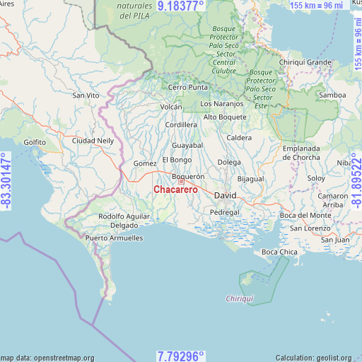
Chacarero GPS coordinates[2]
8° 29' 20.364" North, 82° 35' 54.024" West
| Map corner | latitude | longitude |
|---|---|---|
| Upper-left | 9.18377°, | -83.30147° |
| Center: | 8.48899°, | -82.59834° |
| Lower-right: | 7.79296°, | -81.89522° |
| Map W x H: | 154.6×154.6 km | = 96.1×96.1mi |
| max Lat: | 9.60898° ⇑47.7% North |
| Chacarero: | 8.48899° |
| min Lat: | ⇓52.3% South 7.26534° |
| min Long | Chacarero | max Long |
| -82.91275° | -82.59834° | -77.38965° |
| W 8.4%⇐ | ⇒91.6% E |
Elevation
Elevation of Chacarero is 159 m = 522 ft, and this is 13.1 m = 43 ft below average elevation for this country.
| Max E: |
2103 m = 6900 ft | 29.6% |
| Avg. | 172.1 m = 565 ft | |
| Chacarero | 159 m = 522 ft | |
Min E: |
-1 m = -3 ft | 70.4% |
See also: Panama elevation on elevation.city.
Geographical zone
Chacarero is located in North Torrid zone (between Equator and Tropic of Cancer). Distance of Equator is 943.9 km =586.5 mi to South.| Distance of | km | miles | from Chacarero |
|---|---|---|---|
| North Pole | 9063.2 | 5631.6 | to North |
| Arctic Circle | 6457.3 | 4012.4 | to North |
| Tropic Cancer | 1662 | 1032.7 | to North |
| Equator | 943.9 | 586.5 | to South |


Nearby cities:
15 places around Chacarero: (largest is in red/bold)
• Boquerón
3.6 km =2.2 mi,  59°
59°
• Bugaba
2.5 km =1.6 mi,  253°
253°
• Bugabita Arriba
5.5 km =3.4 mi,  310°
310°
• Bágala
8.4 km =5.2 mi,  109°
109°
• El Tejar
7.2 km =4.5 mi,  157°
157°
• La Concepción
3.4 km =2.1 mi,  319°
319°
• La Estrella
8.6 km =5.3 mi,  290°
290°
• La Meseta
7.1 km =4.4 mi,  3°
3°
• Loma de San Pedro
8.7 km =5.4 mi,  144°
144°
• San Carlos
10.3 km =6.4 mi,  72°
72°
• San Miguel del Yuco
7 km =4.3 mi,  334°
334°
• Sioguí Abajo
7.4 km =4.6 mi,  268°
268°
• Sortova
8.7 km =5.4 mi, 317°
• Tijeras
4.4 km =2.7 mi, 110°
• Veladero
7.1 km =4.4 mi,  150°
150°
Sources, notices
• [Note1] Compared only with cities in Panama existing in our database
• [Src1] Map data: © OpenStreetMap contributors (CC-BY-SA)
• [Src2] Other city data from geonames.org with taken over terms of usage.
• [Src3] Geographical zone / Annual Mean Temperature by Robert A. Rohde @ Wikipedia
