La Encantada geodata
La Encantada (Colón) is a seat of a third-order administrative division; located in Panama in America/Panama (GMT-5) time zone. In our database, there are 694 cities with bigger population. Compared to other cities in Panama, 86.5% of cities are located further ↓South; 67.9% of cities are located further ←West and 96.3% of cities have higher elevation than La Encantada. Note1


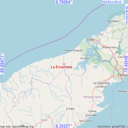
La Encantada GPS coordinates[2]
9° 5' 13.308" North, 80° 11' 29.688" West
| Map corner | latitude | longitude |
|---|---|---|
| Upper-left | 9.78064°, | -80.89471° |
| Center: | 9.08703°, | -80.19158° |
| Lower-right: | 8.39207°, | -79.48846° |
| Map W x H: | 154.4×154.4 km | = 95.9×95.9mi |
| max Lat: | 9.60898° ⇑13.5% North |
| La Encantada: | 9.08703° |
| min Lat: | ⇓86.5% South 7.26534° |
| min Long | La Encantada | max Long |
| -82.91275° | -80.19158° | -77.38965° |
| W 67.9%⇐ | ⇒32.1% E |
Elevation
Elevation of La Encantada is 6 m = 20 ft, and this is 166.1 m = 545 ft below average elevation for this country.
| Max E: |
2103 m = 6900 ft | 96.3% |
| Avg. | 172.1 m = 565 ft | |
| La Encantada | 6 m = 20 ft | |
Min E: |
-1 m = -3 ft | 3.7% |
See also: Panama elevation on elevation.city.
Geographical zone
La Encantada is located in North Torrid zone (between Equator and Tropic of Cancer). Distance of Equator is 1010.4 km =627.8 mi to South.| Distance of | km | miles | from La Encantada |
|---|---|---|---|
| North Pole | 8996.7 | 5590.3 | to North |
| Arctic Circle | 6390.8 | 3971.1 | to North |
| Tropic Cancer | 1595.5 | 991.4 | to North |
| Equator | 1010.4 | 627.8 | to South |


Nearby cities:
15 places around La Encantada: (largest is in red/bold)
• Achiote
23.9 km =14.9 mi,  54°
54°
• Boca de Río Indio
10.7 km =6.6 mi,  0°
0°
• Boca del Guásimo
15.6 km =9.7 mi,  254°
254°
• Cirí de Los Sotos
16.8 km =10.4 mi,  139°
139°
• Cuipo
15.8 km =9.8 mi,  97°
97°
• El Guabo
11.9 km =7.4 mi,  94°
94°
• Escobal
25.7 km =16 mi,  75°
75°
• Gobea
10.3 km =6.4 mi,  321°
321°
• Las Marias
22.3 km =13.9 mi,  187°
187°
• Miguel de La Borda
13.7 km =8.5 mi,  298°
298°
• Nuevo Chagres
20.8 km =12.9 mi,  35°
35°
• Palmas Bellas
19.6 km =12.2 mi, 36°
• Puerto Escondido
16.4 km =10.2 mi, 43°
• Salud
14 km =8.7 mi,  27°
27°
• Santa Rosa Número Uno
26.7 km =16.6 mi,  157°
157°
Sources, notices
• [Note1] Compared only with cities in Panama existing in our database
• [Src1] Map data: © OpenStreetMap contributors (CC-BY-SA)
• [Src2] Other city data from geonames.org with taken over terms of usage.
• [Src3] Geographical zone / Annual Mean Temperature by Robert A. Rohde @ Wikipedia
