El Guabo geodata
El Guabo (Colón) is a seat of a third-order administrative division; located in Panama in America/Panama (GMT-5) time zone. With population of 359 people, there are 535 cities with bigger population in this country. Compared to other cities in Panama, 86% of cities are located further ↓South; 71.4% of cities are located further ←West and 50.1% of cities have higher elevation than El Guabo. Note1


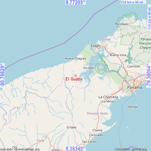
El Guabo GPS coordinates[2]
9° 4' 42.312" North, 80° 4' 59.376" West
| Map corner | latitude | longitude |
|---|---|---|
| Upper-left | 9.77205°, | -80.78629° |
| Center: | 9.07842°, | -80.08316° |
| Lower-right: | 8.38345°, | -79.38004° |
| Map W x H: | 154.4×154.4 km | = 95.9×95.9mi |
| max Lat: | 9.60898° ⇑14% North |
| El Guabo: | 9.07842° |
| min Lat: | ⇓86% South 7.26534° |
| min Long | El Guabo | max Long |
| -82.91275° | -80.08316° | -77.38965° |
| W 71.4%⇐ | ⇒28.6% E |
Elevation
Elevation of El Guabo is 72 m = 236 ft, and this is 100.1 m = 328 ft below average elevation for this country.
| Max E: |
2103 m = 6900 ft | 50.1% |
| Avg. | 172.1 m = 565 ft | |
| El Guabo | 72 m = 236 ft | |
Min E: |
-1 m = -3 ft | 49.9% |
See also: Panama elevation on elevation.city.
Geographical zone
El Guabo is located in North Torrid zone (between Equator and Tropic of Cancer). Distance of Equator is 1009.4 km =627.2 mi to South.| Distance of | km | miles | from El Guabo |
|---|---|---|---|
| North Pole | 8997.6 | 5590.8 | to North |
| Arctic Circle | 6391.7 | 3971.6 | to North |
| Tropic Cancer | 1596.5 | 992 | to North |
| Equator | 1009.4 | 627.2 | to South |


Nearby cities:
15 places around El Guabo: (largest is in red/bold)
• Achiote
16.6 km =10.3 mi,  27°
27°
• Arenosa
15.1 km =9.4 mi,  106°
106°
• Arosemena
17.5 km =10.9 mi,  132°
132°
• Boca de Río Indio
16.6 km =10.3 mi,  314°
314°
• Cerro Cama
20.1 km =12.5 mi, 106°
• Cirí de Los Sotos
11.9 km =7.4 mi,  184°
184°
• Cuipo
3.9 km =2.4 mi, 105°
• Escobal
14.9 km =9.3 mi,  60°
60°
• Gobea
20.5 km =12.7 mi,  296°
296°
• La Encantada
11.9 km =7.4 mi,  274°
274°
• Lagarterita
18.6 km =11.6 mi,  89°
89°
• Nuevo Chagres
17.9 km =11.1 mi,  0°
0°
• Palmas Bellas
16.7 km =10.4 mi,  359°
359°
• Puerto Escondido
12.8 km =8 mi, 357°
• Salud
14.4 km =8.9 mi,  338°
338°
Sources, notices
• [Note1] Compared only with cities in Panama existing in our database
• [Src1] Map data: © OpenStreetMap contributors (CC-BY-SA)
• [Src2] Other city data from geonames.org with taken over terms of usage.
• [Src3] Geographical zone / Annual Mean Temperature by Robert A. Rohde @ Wikipedia
