Achiote geodata
Achiote (Colón) is a seat of a third-order administrative division; located in Panama in America/Panama (GMT-5) time zone. In our database, there are 694 cities with bigger population. Compared to other cities in Panama, 91.9% of cities are located further ↓South; 72.7% of cities are located further ←West and 85.5% of cities have higher elevation than Achiote. Note1


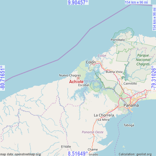
Achiote GPS coordinates[2]
9° 12' 40.356" North, 80° 0' 48.168" West
| Map corner | latitude | longitude |
|---|---|---|
| Upper-left | 9.90457°, | -80.71651° |
| Center: | 9.21121°, | -80.01338° |
| Lower-right: | 8.51649°, | -79.31026° |
| Map W x H: | 154.3×154.3 km | = 95.9×95.9mi |
| max Lat: | 9.60898° ⇑8.1% North |
| Achiote: | 9.21121° |
| min Lat: | ⇓91.9% South 7.26534° |
| min Long | Achiote | max Long |
| -82.91275° | -80.01338° | -77.38965° |
| W 72.7%⇐ | ⇒27.3% E |
Elevation
Elevation of Achiote is 17 m = 56 ft, and this is 155.1 m = 509 ft below average elevation for this country.
| Max E: |
2103 m = 6900 ft | 85.5% |
| Avg. | 172.1 m = 565 ft | |
| Achiote | 17 m = 56 ft | |
Min E: |
-1 m = -3 ft | 14.5% |
See also: Panama elevation on elevation.city.
Geographical zone
Achiote is located in North Torrid zone (between Equator and Tropic of Cancer). Distance of Equator is 1024.2 km =636.4 mi to South.| Distance of | km | miles | from Achiote |
|---|---|---|---|
| North Pole | 8982.9 | 5581.7 | to North |
| Arctic Circle | 6377 | 3962.5 | to North |
| Tropic Cancer | 1581.7 | 982.8 | to North |
| Equator | 1024.2 | 636.4 | to South |


Nearby cities:
15 places around Achiote: (largest is in red/bold)
• Arenosa
20.2 km =12.6 mi,  160°
160°
• Boca de Río Indio
19.7 km =12.2 mi,  260°
260°
• Colón
20.2 km =12.6 mi,  37°
37°
• Cristóbal
19.7 km =12.2 mi, 37°
• Cuipo
16.3 km =10.1 mi,  193°
193°
• El Guabo
16.6 km =10.3 mi,  207°
207°
• Escobal
9.2 km =5.7 mi,  144°
144°
• Lagarterita
18.3 km =11.4 mi, 143°
• Las Margaritas
18.6 km =11.6 mi,  46°
46°
• Nueva Providencia
22.5 km =14 mi,  75°
75°
• Nuevo Chagres
8.2 km =5.1 mi,  292°
292°
• Palmas Bellas
8.1 km =5 mi,  283°
283°
• Panama City
19.1 km =11.9 mi, 44°
• Puerto Escondido
8.5 km =5.3 mi, 256°
• Salud
13.1 km =8.1 mi, 263°
Sources, notices
• [Note1] Compared only with cities in Panama existing in our database
• [Src1] Map data: © OpenStreetMap contributors (CC-BY-SA)
• [Src2] Other city data from geonames.org with taken over terms of usage.
• [Src3] Geographical zone / Annual Mean Temperature by Robert A. Rohde @ Wikipedia
