Jacú geodata
Jacú (Chiriquí) is a populated place; located in Panama in America/Panama (GMT-5) time zone. With population of 840 people, there are 301 cities with bigger population in this country. Compared to other cities in Panama, 51.8% of cities are located further ↓South; 97.1% of cities are located further →East and 66% of cities have higher elevation than Jacú. Note1


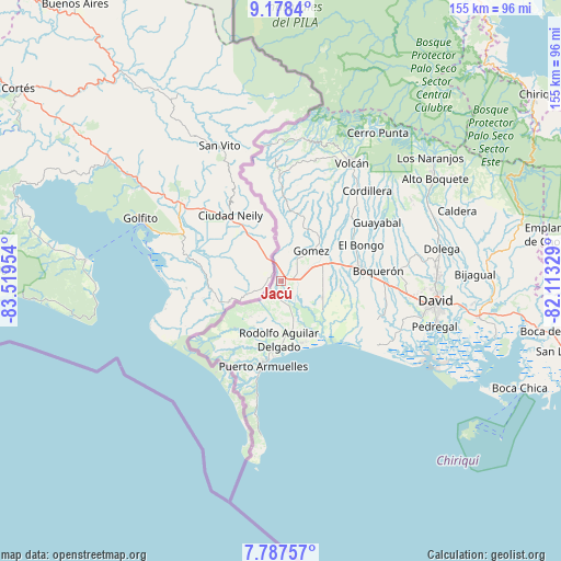
Jacú GPS coordinates[2]
8° 29' 0.996" North, 82° 48' 59.076" West
| Map corner | latitude | longitude |
|---|---|---|
| Upper-left | 9.1784°, | -83.51954° |
| Center: | 8.48361°, | -82.81641° |
| Lower-right: | 7.78757°, | -82.11329° |
| Map W x H: | 154.6×154.6 km | = 96.1×96.1mi |
| max Lat: | 9.60898° ⇑48.2% North |
| Jacú: | 8.48361° |
| min Lat: | ⇓51.8% South 7.26534° |
| min Long | Jacú | max Long |
| -82.91275° | -82.81641° | -77.38965° |
| W 2.9%⇐ | ⇒97.1% E |
Elevation
Elevation of Jacú is 42 m = 138 ft, and this is 130.1 m = 427 ft below average elevation for this country.
| Max E: |
2103 m = 6900 ft | 66% |
| Avg. | 172.1 m = 565 ft | |
| Jacú | 42 m = 138 ft | |
Min E: |
-1 m = -3 ft | 34% |
See also: Panama elevation on elevation.city.
Geographical zone
Jacú is located in North Torrid zone (between Equator and Tropic of Cancer). Distance of Equator is 943.3 km =586.1 mi to South.| Distance of | km | miles | from Jacú |
|---|---|---|---|
| North Pole | 9063.8 | 5632 | to North |
| Arctic Circle | 6457.9 | 4012.8 | to North |
| Tropic Cancer | 1662.6 | 1033.1 | to North |
| Equator | 943.3 | 586.1 | to South |


Nearby cities:
15 places around Jacú: (largest is in red/bold)
• Aserrío de Gariché
2.8 km =1.7 mi,  92°
92°
• Berba
11 km =6.8 mi,  178°
178°
• Celmira
6.5 km =4 mi,  15°
15°
• Chuchupate
7.6 km =4.7 mi,  224°
224°
• Cuervito Abajo
3.3 km =2.1 mi,  232°
232°
• El Roble
5.2 km =3.2 mi,  62°
62°
• Finca Balsa
10.8 km =6.7 mi,  235°
235°
• Gariché
3.6 km =2.2 mi, 90°
• La Esperanza
9.3 km =5.8 mi,  163°
163°
• Paso Canoas Arriba
9.1 km =5.7 mi,  356°
356°
• Portón
9.3 km =5.8 mi, 21°
• Progreso
4.8 km =3 mi,  210°
210°
• San Isidro
5.3 km =3.3 mi,  347°
347°
• Santa María
4.9 km =3 mi, 215°
• Santo Domingo
11.7 km =7.3 mi,  76°
76°
Sources, notices
• [Note1] Compared only with cities in Panama existing in our database
• [Src1] Map data: © OpenStreetMap contributors (CC-BY-SA)
• [Src2] Other city data from geonames.org with taken over terms of usage.
• [Src3] Geographical zone / Annual Mean Temperature by Robert A. Rohde @ Wikipedia
