La Esperanza geodata
La Esperanza (Chiriquí) is a seat of a third-order administrative division; located in Panama in America/Panama (GMT-5) time zone. With population of 1,890 people, there are 129 cities with bigger population in this country. Compared to other cities in Panama, 57.1% of cities are located further ↑North; 96.3% of cities are located further →East and 81.5% of cities have higher elevation than La Esperanza. Note1


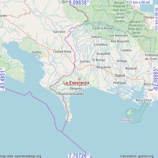
La Esperanza GPS coordinates[2]
8° 24' 12.384" North, 82° 47' 31.092" West
| Map corner | latitude | longitude |
|---|---|---|
| Upper-left | 9.09838°, | -83.4951° |
| Center: | 8.40344°, | -82.79197° |
| Lower-right: | 7.70726°, | -82.08885° |
| Map W x H: | 154.7×154.7 km | = 96.1×96.1mi |
| max Lat: | 9.60898° ⇑57.1% North |
| La Esperanza: | 8.40344° |
| min Lat: | ⇓42.9% South 7.26534° |
| min Long | La Esperanza | max Long |
| -82.91275° | -82.79197° | -77.38965° |
| W 3.7%⇐ | ⇒96.3% E |
Elevation
Elevation of La Esperanza is 21 m = 69 ft, and this is 151.1 m = 496 ft below average elevation for this country.
| Max E: |
2103 m = 6900 ft | 81.5% |
| Avg. | 172.1 m = 565 ft | |
| La Esperanza | 21 m = 69 ft | |
Min E: |
-1 m = -3 ft | 18.5% |
See also: Panama elevation on elevation.city.
Geographical zone
La Esperanza is located in North Torrid zone (between Equator and Tropic of Cancer). Distance of Equator is 934.4 km =580.6 mi to South.| Distance of | km | miles | from La Esperanza |
|---|---|---|---|
| North Pole | 9072.7 | 5637.5 | to North |
| Arctic Circle | 6466.8 | 4018.3 | to North |
| Tropic Cancer | 1671.5 | 1038.6 | to North |
| Equator | 934.4 | 580.6 | to South |


Nearby cities:
15 places around La Esperanza: (largest is in red/bold)
• Aserrío de Gariché
8.8 km =5.5 mi,  0°
0°
• Berba
3.1 km =1.9 mi,  228°
228°
• Chuchupate
8.7 km =5.4 mi,  293°
293°
• Cuervito Abajo
8.7 km =5.4 mi,  322°
322°
• Divalá
8.7 km =5.4 mi,  84°
84°
• Finca Blanco
9.4 km =5.8 mi,  253°
253°
• Finca Corredor
11.2 km =7 mi, 233°
• Gariché
8.9 km =5.5 mi,  6°
6°
• Jacú
9.3 km =5.8 mi,  343°
343°
• Majagual
7.6 km =4.7 mi,  159°
159°
• Manaca Civil
9.1 km =5.7 mi,  196°
196°
• Manaca Norte
8 km =5 mi,  194°
194°
• Progreso
7 km =4.3 mi,  313°
313°
• San Valentín
4.2 km =2.6 mi, 161°
• Santa María
7.4 km =4.6 mi, 311°
Sources, notices
• [Note1] Compared only with cities in Panama existing in our database
• [Src1] Map data: © OpenStreetMap contributors (CC-BY-SA)
• [Src2] Other city data from geonames.org with taken over terms of usage.
• [Src3] Geographical zone / Annual Mean Temperature by Robert A. Rohde @ Wikipedia
