El Roble geodata
El Roble (Chiriquí) is a populated place; located in Panama in America/Panama (GMT-5) time zone. With population of 666 people, there are 372 cities with bigger population in this country. Compared to other cities in Panama, 53.1% of cities are located further ↓South; 95.6% of cities are located further →East and 64.9% of cities have lower elevation than El Roble. Note1


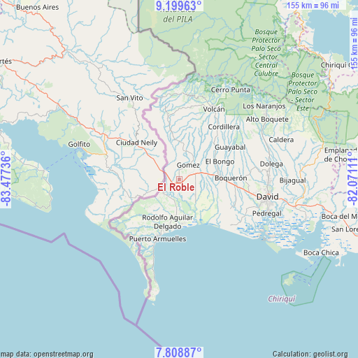
El Roble GPS coordinates[2]
8° 30' 17.568" North, 82° 46' 27.228" West
| Map corner | latitude | longitude |
|---|---|---|
| Upper-left | 9.19963°, | -83.47736° |
| Center: | 8.50488°, | -82.77423° |
| Lower-right: | 7.80887°, | -82.07111° |
| Map W x H: | 154.6×154.6 km | = 96.1×96.1mi |
| max Lat: | 9.60898° ⇑46.9% North |
| El Roble: | 8.50488° |
| min Lat: | ⇓53.1% South 7.26534° |
| min Long | El Roble | max Long |
| -82.91275° | -82.77423° | -77.38965° |
| W 4.4%⇐ | ⇒95.6% E |
Elevation
Elevation of El Roble is 124 m = 407 ft, and this is 48.1 m = 158 ft below average elevation for this country.
| Max E: |
2103 m = 6900 ft | 35.1% |
| Avg. | 172.1 m = 565 ft | |
| El Roble | 124 m = 407 ft | |
Min E: |
-1 m = -3 ft | 64.9% |
See also: Panama elevation on elevation.city.
Geographical zone
El Roble is located in North Torrid zone (between Equator and Tropic of Cancer). Distance of Equator is 945.7 km =587.6 mi to South.| Distance of | km | miles | from El Roble |
|---|---|---|---|
| North Pole | 9061.4 | 5630.5 | to North |
| Arctic Circle | 6455.5 | 4011.3 | to North |
| Tropic Cancer | 1660.3 | 1031.7 | to North |
| Equator | 945.7 | 587.6 | to South |


Nearby cities:
15 places around El Roble: (largest is in red/bold)
• Aserrío de Gariché
3.1 km =1.9 mi,  216°
216°
• Celmira
4.9 km =3 mi,  324°
324°
• Cuervito Abajo
8.5 km =5.3 mi,  239°
239°
• Gariché
2.6 km =1.6 mi,  202°
202°
• Gómez
7.2 km =4.5 mi,  30°
30°
• Jacú
5.2 km =3.2 mi, 242°
• La Estrella
11.3 km =7 mi,  83°
83°
• Paso Canoas Arriba
8.5 km =5.3 mi, 321°
• Portón
6.4 km =4 mi,  349°
349°
• Progreso
9.6 km =6 mi,  227°
227°
• San Isidro
6.5 km =4 mi,  295°
295°
• Santa Marta
8.4 km =5.2 mi, 82°
• Santa María
9.8 km =6.1 mi, 229°
• Santo Domingo
6.7 km =4.2 mi,  87°
87°
• Sioguí Arriba
10.4 km =6.5 mi,  68°
68°
Sources, notices
• [Note1] Compared only with cities in Panama existing in our database
• [Src1] Map data: © OpenStreetMap contributors (CC-BY-SA)
• [Src2] Other city data from geonames.org with taken over terms of usage.
• [Src3] Geographical zone / Annual Mean Temperature by Robert A. Rohde @ Wikipedia
