Finca Balsa geodata
Finca Balsa (Chiriquí) is a populated place; located in Panama in America/Panama (GMT-5) time zone. With population of 502 people, there are 486 cities with bigger population in this country. Compared to other cities in Panama, 55.2% of cities are located further ↑North; 99.7% of cities are located further →East and 81.5% of cities have higher elevation than Finca Balsa. Note1


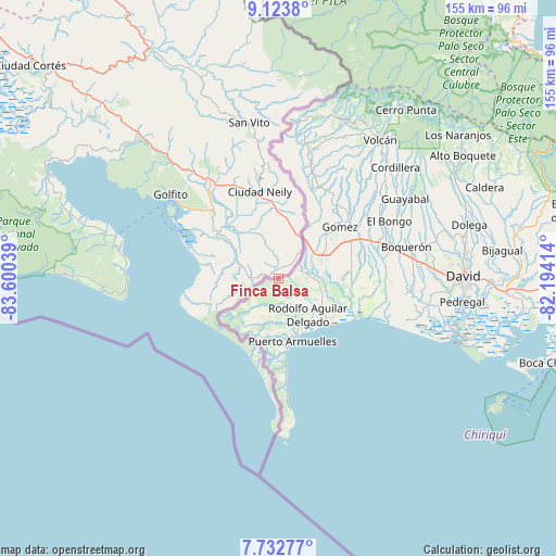
Finca Balsa GPS coordinates[2]
8° 25' 44.076" North, 82° 53' 50.136" West
| Map corner | latitude | longitude |
|---|---|---|
| Upper-left | 9.1238°, | -83.60039° |
| Center: | 8.42891°, | -82.89726° |
| Lower-right: | 7.73277°, | -82.19414° |
| Map W x H: | 154.7×154.7 km | = 96.1×96.1mi |
| max Lat: | 9.60898° ⇑55.2% North |
| Finca Balsa: | 8.42891° |
| min Lat: | ⇓44.8% South 7.26534° |
| min Long | Finca Balsa | max Long |
| -82.91275° | -82.89726° | -77.38965° |
| W 0.3%⇐ | ⇒99.7% E |
Elevation
Elevation of Finca Balsa is 21 m = 69 ft, and this is 151.1 m = 496 ft below average elevation for this country.
| Max E: |
2103 m = 6900 ft | 81.5% |
| Avg. | 172.1 m = 565 ft | |
| Finca Balsa | 21 m = 69 ft | |
Min E: |
-1 m = -3 ft | 18.5% |
See also: Panama elevation on elevation.city.
Geographical zone
Finca Balsa is located in North Torrid zone (between Equator and Tropic of Cancer). Distance of Equator is 937.2 km =582.3 mi to South.| Distance of | km | miles | from Finca Balsa |
|---|---|---|---|
| North Pole | 9069.9 | 5635.8 | to North |
| Arctic Circle | 6464 | 4016.5 | to North |
| Tropic Cancer | 1668.7 | 1036.9 | to North |
| Equator | 937.2 | 582.3 | to South |


Nearby cities:
15 places around Finca Balsa: (largest is in red/bold)
• Aserrío de Gariché
13.1 km =8.1 mi,  62°
62°
• Berba
10.5 km =6.5 mi,  117°
117°
• Chuchupate
3.7 km =2.3 mi,  80°
80°
• Cuervito Abajo
7.5 km =4.7 mi, 56°
• Finca Blanco
6 km =3.7 mi,  154°
154°
• Finca Corredor
9.9 km =6.2 mi,  164°
164°
• Gariché
13.9 km =8.6 mi, 64°
• Jacú
10.8 km =6.7 mi, 55°
• La Esperanza
11.9 km =7.4 mi,  103°
103°
• Manaca Norte
14.2 km =8.8 mi,  137°
137°
• Progreso
6.7 km =4.2 mi,  72°
72°
• San Bartolo Línea
12.9 km =8 mi,  172°
172°
• San Isidro
13.7 km =8.5 mi,  34°
34°
• San Valentín
14.6 km =9.1 mi, 117°
• Santa María
6.4 km =4 mi, 70°
Sources, notices
• [Note1] Compared only with cities in Panama existing in our database
• [Src1] Map data: © OpenStreetMap contributors (CC-BY-SA)
• [Src2] Other city data from geonames.org with taken over terms of usage.
• [Src3] Geographical zone / Annual Mean Temperature by Robert A. Rohde @ Wikipedia
