La Laja geodata
La Laja (Los Santos) is a seat of a third-order administrative division; located in Panama in America/Panama (GMT-5) time zone. With population of 383 people, there are 527 cities with bigger population in this country. Compared to other cities in Panama, 92.9% of cities are located further ↑North; 64.6% of cities are located further ←West and 53.3% of cities have higher elevation than La Laja. Note1


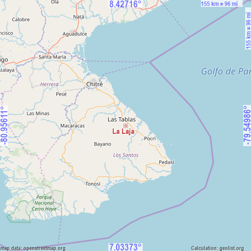
La Laja GPS coordinates[2]
7° 43' 51.672" North, 80° 15' 10.728" West
| Map corner | latitude | longitude |
|---|---|---|
| Upper-left | 8.42716°, | -80.95611° |
| Center: | 7.73102°, | -80.25298° |
| Lower-right: | 7.03373°, | -79.54986° |
| Map W x H: | 154.9×154.9 km | = 96.3×96.3mi |
| max Lat: | 9.60898° ⇑92.9% North |
| La Laja: | 7.73102° |
| min Lat: | ⇓7.1% South 7.26534° |
| min Long | La Laja | max Long |
| -82.91275° | -80.25298° | -77.38965° |
| W 64.6%⇐ | ⇒35.4% E |
Elevation
Elevation of La Laja is 65 m = 213 ft, and this is 107.1 m = 351 ft below average elevation for this country.
| Max E: |
2103 m = 6900 ft | 53.3% |
| Avg. | 172.1 m = 565 ft | |
| La Laja | 65 m = 213 ft | |
Min E: |
-1 m = -3 ft | 46.7% |
See also: Panama elevation on elevation.city.
Geographical zone
La Laja is located in North Torrid zone (between Equator and Tropic of Cancer). Distance of Equator is 859.6 km =534.1 mi to South.| Distance of | km | miles | from La Laja |
|---|---|---|---|
| North Pole | 9147.5 | 5684 | to North |
| Arctic Circle | 6541.6 | 4064.8 | to North |
| Tropic Cancer | 1746.3 | 1085.1 | to North |
| Equator | 859.6 | 534.1 | to South |


Nearby cities:
15 places around La Laja: (largest is in red/bold)
• Bella Vista
3 km =1.9 mi,  45°
45°
• El Carate
4.8 km =3 mi,  270°
270°
• El Cocal
3 km =1.9 mi,  282°
282°
• El Manantial
5.8 km =3.6 mi,  6°
6°
• El Pedregoso
9.3 km =5.8 mi,  242°
242°
• La Palma
7.8 km =4.8 mi,  127°
127°
• La Tiza
4.9 km =3 mi,  297°
297°
• Las Palmitas
5.9 km =3.7 mi,  310°
310°
• Las Tablas
4.5 km =2.8 mi,  327°
327°
• Las Tablas Abajo
7.2 km =4.5 mi,  0°
0°
• Perales
9.3 km =5.8 mi, 301°
• Peña Blanca
3.6 km =2.2 mi,  248°
248°
• San José
6.4 km =4 mi,  171°
171°
• Santo Domingo
2.1 km =1.3 mi,  36°
36°
• Sesteadero
1 km =0.6 mi,  29°
29°
Sources, notices
• [Note1] Compared only with cities in Panama existing in our database
• [Src1] Map data: © OpenStreetMap contributors (CC-BY-SA)
• [Src2] Other city data from geonames.org with taken over terms of usage.
• [Src3] Geographical zone / Annual Mean Temperature by Robert A. Rohde @ Wikipedia
