El Cocal geodata
El Cocal (Los Santos) is a seat of a third-order administrative division; located in Panama in America/Panama (GMT-5) time zone. With population of 926 people, there are 275 cities with bigger population in this country. Compared to other cities in Panama, 92.4% of cities are located further ↑North; 63.1% of cities are located further ←West and 50.5% of cities have lower elevation than El Cocal. Note1


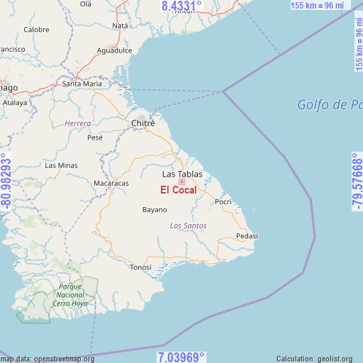
El Cocal GPS coordinates[2]
7° 44' 13.092" North, 80° 16' 47.28" West
| Map corner | latitude | longitude |
|---|---|---|
| Upper-left | 8.4331°, | -80.98293° |
| Center: | 7.73697°, | -80.2798° |
| Lower-right: | 7.03969°, | -79.57668° |
| Map W x H: | 154.9×154.9 km | = 96.3×96.3mi |
| max Lat: | 9.60898° ⇑92.4% North |
| El Cocal: | 7.73697° |
| min Lat: | ⇓7.6% South 7.26534° |
| min Long | El Cocal | max Long |
| -82.91275° | -80.2798° | -77.38965° |
| W 63.1%⇐ | ⇒36.9% E |
Elevation
Elevation of El Cocal is 74 m = 243 ft, and this is 98.1 m = 322 ft below average elevation for this country.
| Max E: |
2103 m = 6900 ft | 49.5% |
| Avg. | 172.1 m = 565 ft | |
| El Cocal | 74 m = 243 ft | |
Min E: |
-1 m = -3 ft | 50.5% |
See also: Panama elevation on elevation.city.
Geographical zone
El Cocal is located in North Torrid zone (between Equator and Tropic of Cancer). Distance of Equator is 860.3 km =534.6 mi to South.| Distance of | km | miles | from El Cocal |
|---|---|---|---|
| North Pole | 9146.8 | 5683.6 | to North |
| Arctic Circle | 6540.9 | 4064.3 | to North |
| Tropic Cancer | 1745.6 | 1084.7 | to North |
| Equator | 860.3 | 534.6 | to South |


Nearby cities:
15 places around El Cocal: (largest is in red/bold)
• Bella Vista
5.3 km =3.3 mi,  74°
74°
• El Carate
2 km =1.2 mi,  251°
251°
• El Manantial
6.2 km =3.9 mi,  35°
35°
• El Pedregoso
7.3 km =4.5 mi,  226°
226°
• La Laja
3 km =1.9 mi,  102°
102°
• La Pasera
7.2 km =4.5 mi,  338°
338°
• La Tiza
2.1 km =1.3 mi,  319°
319°
• Las Palmitas
3.5 km =2.2 mi,  334°
334°
• Las Tablas
3.1 km =1.9 mi,  10°
10°
• Las Tablas Abajo
7.2 km =4.5 mi,  24°
24°
• Perales
6.5 km =4 mi,  310°
310°
• Peña Blanca
2 km =1.2 mi,  192°
192°
• San José
8 km =5 mi,  150°
150°
• Santo Domingo
4.3 km =2.7 mi,  76°
76°
• Sesteadero
3.5 km =2.2 mi,  86°
86°
Sources, notices
• [Note1] Compared only with cities in Panama existing in our database
• [Src1] Map data: © OpenStreetMap contributors (CC-BY-SA)
• [Src2] Other city data from geonames.org with taken over terms of usage.
• [Src3] Geographical zone / Annual Mean Temperature by Robert A. Rohde @ Wikipedia
