Villa Unida geodata
Villa Unida (Panamá) is a populated place; located in Panama in America/Panama (GMT-5) time zone. With population of 14,854 people, there are 28 cities with bigger population in this country. Compared to other cities in Panama, 91.2% of cities are located further ↓South; 84.6% of cities are located further ←West and 53.5% of cities have lower elevation than Villa Unida. Note1


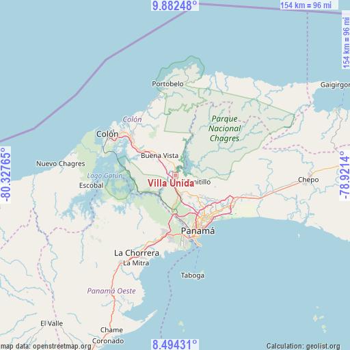
Villa Unida GPS coordinates[2]
9° 11' 20.688" North, 79° 37' 28.272" West
| Map corner | latitude | longitude |
|---|---|---|
| Upper-left | 9.88248°, | -80.32765° |
| Center: | 9.18908°, | -79.62452° |
| Lower-right: | 8.49431°, | -78.9214° |
| Map W x H: | 154.4×154.4 km | = 95.9×95.9mi |
| max Lat: | 9.60898° ⇑8.8% North |
| Villa Unida: | 9.18908° |
| min Lat: | ⇓91.2% South 7.26534° |
| min Long | Villa Unida | max Long |
| -82.91275° | -79.62452° | -77.38965° |
| W 84.6%⇐ | ⇒15.4% E |
Elevation
Elevation of Villa Unida is 83 m = 272 ft, and this is 89.1 m = 292 ft below average elevation for this country.
| Max E: |
2103 m = 6900 ft | 46.5% |
| Avg. | 172.1 m = 565 ft | |
| Villa Unida | 83 m = 272 ft | |
Min E: |
-1 m = -3 ft | 53.5% |
See also: Panama elevation on elevation.city.
Geographical zone
Villa Unida is located in North Torrid zone (between Equator and Tropic of Cancer). Distance of Equator is 1021.7 km =634.9 mi to South.| Distance of | km | miles | from Villa Unida |
|---|---|---|---|
| North Pole | 8985.3 | 5583.2 | to North |
| Arctic Circle | 6379.4 | 3964 | to North |
| Tropic Cancer | 1584.2 | 984.4 | to North |
| Equator | 1021.7 | 634.9 | to South |


Nearby cities:
15 places around Villa Unida: (largest is in red/bold)
• Alcalde Díaz
10.7 km =6.6 mi,  135°
135°
• Buena Vista
12.2 km =7.6 mi,  320°
320°
• Caimitillo
10 km =6.2 mi,  111°
111°
• Calzada Larga
7.1 km =4.4 mi,  104°
104°
• Chilibre
4.3 km =2.7 mi,  174°
174°
• El Giral
9.7 km =6 mi,  309°
309°
• El Valle de la Unión
6.5 km =4 mi, 323°
• Gatuncillo
6.6 km =4.1 mi,  336°
336°
• Nuevo San Juan
5.8 km =3.6 mi, 308°
• Nuevo Vigía
6.2 km =3.9 mi,  17°
17°
• Palenque
6.5 km =4 mi,  287°
287°
• Río Duque
9.6 km =6 mi, 321°
• San Antonio
8.7 km =5.4 mi, 102°
• San Vicente
8.8 km =5.5 mi,  160°
160°
• Sardinilla
12.3 km =7.6 mi,  352°
352°
Sources, notices
• [Note1] Compared only with cities in Panama existing in our database
• [Src1] Map data: © OpenStreetMap contributors (CC-BY-SA)
• [Src2] Other city data from geonames.org with taken over terms of usage.
• [Src3] Geographical zone / Annual Mean Temperature by Robert A. Rohde @ Wikipedia
