Chilibre geodata
Chilibre (Panamá) is a seat of a third-order administrative division; located in Panama in America/Panama (GMT-5) time zone. With population of 33,536 people, there are 12 cities with bigger population in this country. Compared to other cities in Panama, 89.3% of cities are located further ↓South; 84.9% of cities are located further ←West and 61.3% of cities have higher elevation than Chilibre. Note1


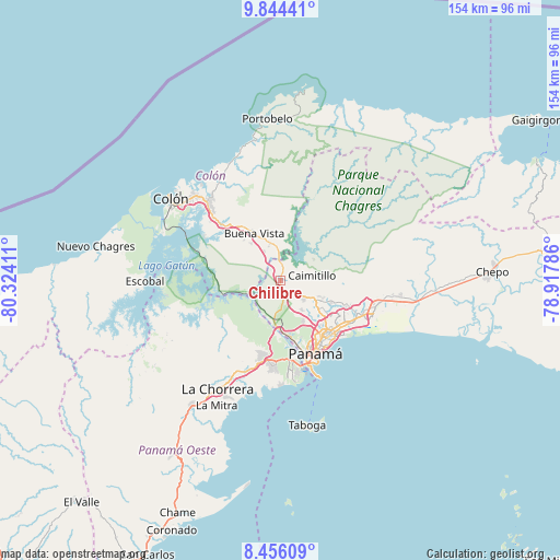
Chilibre GPS coordinates[2]
9° 9' 3.348" North, 79° 37' 15.528" West
| Map corner | latitude | longitude |
|---|---|---|
| Upper-left | 9.84441°, | -80.32411° |
| Center: | 9.15093°, | -79.62098° |
| Lower-right: | 8.45609°, | -78.91786° |
| Map W x H: | 154.4×154.4 km | = 95.9×95.9mi |
| max Lat: | 9.60898° ⇑10.7% North |
| Chilibre: | 9.15093° |
| min Lat: | ⇓89.3% South 7.26534° |
| min Long | Chilibre | max Long |
| -82.91275° | -79.62098° | -77.38965° |
| W 84.9%⇐ | ⇒15.1% E |
Elevation
Elevation of Chilibre is 50 m = 164 ft, and this is 122.1 m = 401 ft below average elevation for this country.
| Max E: |
2103 m = 6900 ft | 61.3% |
| Avg. | 172.1 m = 565 ft | |
| Chilibre | 50 m = 164 ft | |
Min E: |
-1 m = -3 ft | 38.7% |
See also: Panama elevation on elevation.city.
Geographical zone
Chilibre is located in North Torrid zone (between Equator and Tropic of Cancer). Distance of Equator is 1017.5 km =632.2 mi to South.| Distance of | km | miles | from Chilibre |
|---|---|---|---|
| North Pole | 8989.6 | 5585.9 | to North |
| Arctic Circle | 6383.7 | 3966.6 | to North |
| Tropic Cancer | 1588.4 | 987 | to North |
| Equator | 1017.5 | 632.2 | to South |


Nearby cities:
15 places around Chilibre: (largest is in red/bold)
• Alcalde Díaz
7.9 km =4.9 mi,  115°
115°
• Caimitillo
8.9 km =5.5 mi,  86°
86°
• Calzada Larga
6.9 km =4.3 mi,  69°
69°
• El Valle de la Unión
10.4 km =6.5 mi,  335°
335°
• Gatuncillo
10.7 km =6.6 mi, 343°
• Gonzalillo
13 km =8.1 mi, 120°
• La Cabima
9.9 km =6.2 mi,  111°
111°
• Las Cumbres
12.3 km =7.6 mi, 123°
• Mocambo Arriba
10.4 km =6.5 mi,  145°
145°
• Nuevo San Juan
9.3 km =5.8 mi,  327°
327°
• Nuevo Vigía
10.3 km =6.4 mi,  8°
8°
• Palenque
9 km =5.6 mi,  313°
313°
• San Antonio
8.4 km =5.2 mi, 73°
• San Vicente
4.8 km =3 mi, 147°
• Villa Unida
4.3 km =2.7 mi,  354°
354°
Sources, notices
• [Note1] Compared only with cities in Panama existing in our database
• [Src1] Map data: © OpenStreetMap contributors (CC-BY-SA)
• [Src2] Other city data from geonames.org with taken over terms of usage.
• [Src3] Geographical zone / Annual Mean Temperature by Robert A. Rohde @ Wikipedia
