Las Tablas Abajo geodata
Las Tablas Abajo (Los Santos) is a populated place; located in Panama in America/Panama (GMT-5) time zone. With population of 538 people, there are 451 cities with bigger population in this country. Compared to other cities in Panama, 90.1% of cities are located further ↑North; 64.7% of cities are located further ←West and 77.3% of cities have higher elevation than Las Tablas Abajo. Note1


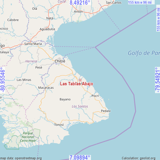
Las Tablas Abajo GPS coordinates[2]
7° 47' 46.068" North, 80° 15' 8.388" West
| Map corner | latitude | longitude |
|---|---|---|
| Upper-left | 8.49216°, | -80.95546° |
| Center: | 7.79613°, | -80.25233° |
| Lower-right: | 7.09894°, | -79.54921° |
| Map W x H: | 154.9×154.9 km | = 96.3×96.3mi |
| max Lat: | 9.60898° ⇑90.1% North |
| Las Tablas Abajo: | 7.79613° |
| min Lat: | ⇓9.9% South 7.26534° |
| min Long | Las Tablas Abaj | max Long |
| -82.91275° | -80.25233° | -77.38965° |
| W 64.7%⇐ | ⇒35.3% E |
Elevation
Elevation of Las Tablas Abajo is 27 m = 89 ft, and this is 145.1 m = 476 ft below average elevation for this country.
| Max E: |
2103 m = 6900 ft | 77.3% |
| Avg. | 172.1 m = 565 ft | |
| Las Tablas Abajo | 27 m = 89 ft | |
Min E: |
-1 m = -3 ft | 22.7% |
See also: Panama elevation on elevation.city.
Geographical zone
Las Tablas Abajo is located in North Torrid zone (between Equator and Tropic of Cancer). Distance of Equator is 866.8 km =538.6 mi to South.| Distance of | km | miles | from Las Tablas Abajo |
|---|---|---|---|
| North Pole | 9140.2 | 5679.5 | to North |
| Arctic Circle | 6534.3 | 4060.2 | to North |
| Tropic Cancer | 1739.1 | 1080.6 | to North |
| Equator | 866.8 | 538.6 | to South |


Nearby cities:
15 places around Las Tablas Abajo: (largest is in red/bold)
• Bella Vista
5.5 km =3.4 mi,  157°
157°
• El Carate
8.7 km =5.4 mi,  214°
214°
• El Cocal
7.2 km =4.5 mi,  204°
204°
• El Manantial
1.6 km =1 mi, 159°
• Guararé
4 km =2.5 mi,  301°
301°
• La Enea
4.8 km =3 mi,  329°
329°
• La Laja
7.2 km =4.5 mi,  180°
180°
• La Pasera
5.6 km =3.5 mi,  271°
271°
• La Tiza
6.7 km =4.2 mi,  221°
221°
• Las Palmitas
5.7 km =3.5 mi,  232°
232°
• Las Tablas
4.3 km =2.7 mi, 215°
• Perales
8.3 km =5.2 mi,  253°
253°
• Peña Blanca
9.2 km =5.7 mi, 202°
• Santo Domingo
5.7 km =3.5 mi,  168°
168°
• Sesteadero
6.4 km =4 mi, 176°
Sources, notices
• [Note1] Compared only with cities in Panama existing in our database
• [Src1] Map data: © OpenStreetMap contributors (CC-BY-SA)
• [Src2] Other city data from geonames.org with taken over terms of usage.
• [Src3] Geographical zone / Annual Mean Temperature by Robert A. Rohde @ Wikipedia
