Sesteadero geodata
Sesteadero (Los Santos) is a seat of a third-order administrative division; located in Panama in America/Panama (GMT-5) time zone. With population of 771 people, there are 334 cities with bigger population in this country. Compared to other cities in Panama, 92.3% of cities are located further ↑North; 65.1% of cities are located further ←West and 64% of cities have higher elevation than Sesteadero. Note1


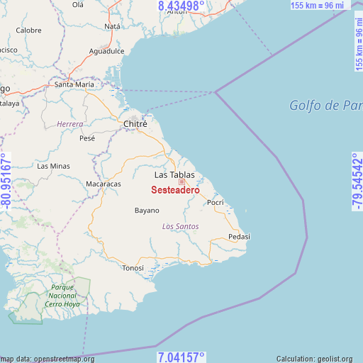
Sesteadero GPS coordinates[2]
7° 44' 19.86" North, 80° 14' 54.744" West
| Map corner | latitude | longitude |
|---|---|---|
| Upper-left | 8.43498°, | -80.95167° |
| Center: | 7.73885°, | -80.24854° |
| Lower-right: | 7.04157°, | -79.54542° |
| Map W x H: | 154.9×154.9 km | = 96.3×96.3mi |
| max Lat: | 9.60898° ⇑92.3% North |
| Sesteadero: | 7.73885° |
| min Lat: | ⇓7.7% South 7.26534° |
| min Long | Sesteadero | max Long |
| -82.91275° | -80.24854° | -77.38965° |
| W 65.1%⇐ | ⇒34.9% E |
Elevation
Elevation of Sesteadero is 47 m = 154 ft, and this is 125.1 m = 410 ft below average elevation for this country.
| Max E: |
2103 m = 6900 ft | 64% |
| Avg. | 172.1 m = 565 ft | |
| Sesteadero | 47 m = 154 ft | |
Min E: |
-1 m = -3 ft | 36% |
See also: Panama elevation on elevation.city.
Geographical zone
Sesteadero is located in North Torrid zone (between Equator and Tropic of Cancer). Distance of Equator is 860.5 km =534.7 mi to South.| Distance of | km | miles | from Sesteadero |
|---|---|---|---|
| North Pole | 9146.6 | 5683.4 | to North |
| Arctic Circle | 6540.7 | 4064.2 | to North |
| Tropic Cancer | 1745.4 | 1084.5 | to North |
| Equator | 860.5 | 534.7 | to South |


Nearby cities:
15 places around Sesteadero: (largest is in red/bold)
• Bella Vista
2.1 km =1.3 mi,  53°
53°
• El Carate
5.4 km =3.4 mi,  260°
260°
• El Cocal
3.5 km =2.2 mi,  266°
266°
• El Manantial
4.9 km =3 mi,  1°
1°
• La Laja
1 km =0.6 mi,  209°
209°
• La Palma
8 km =5 mi,  134°
134°
• La Pasera
8.9 km =5.5 mi,  317°
317°
• La Tiza
5 km =3.1 mi,  285°
285°
• Las Palmitas
5.8 km =3.6 mi,  300°
300°
• Las Tablas
4.1 km =2.5 mi,  314°
314°
• Las Tablas Abajo
6.4 km =4 mi,  356°
356°
• Perales
9.3 km =5.8 mi, 295°
• Peña Blanca
4.4 km =2.7 mi,  240°
240°
• San José
7.2 km =4.5 mi,  176°
176°
• Santo Domingo
1.1 km =0.7 mi,  42°
42°
Sources, notices
• [Note1] Compared only with cities in Panama existing in our database
• [Src1] Map data: © OpenStreetMap contributors (CC-BY-SA)
• [Src2] Other city data from geonames.org with taken over terms of usage.
• [Src3] Geographical zone / Annual Mean Temperature by Robert A. Rohde @ Wikipedia
