El Calabacito geodata
El Calabacito (Herrera) is a seat of a third-order administrative division; located in Panama in America/Panama (GMT-5) time zone. With population of 134 people, there are 638 cities with bigger population in this country. Compared to other cities in Panama, 93.5% of cities are located further ↑North; 50.6% of cities are located further →East and 77.3% of cities have lower elevation than El Calabacito. Note1


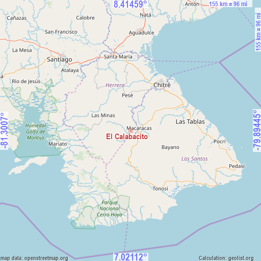
El Calabacito GPS coordinates[2]
7° 43' 6.348" North, 80° 35' 51.252" West
| Map corner | latitude | longitude |
|---|---|---|
| Upper-left | 8.41459°, | -81.3007° |
| Center: | 7.71843°, | -80.59757° |
| Lower-right: | 7.02112°, | -79.89445° |
| Map W x H: | 154.9×154.9 km | = 96.3×96.3mi |
| max Lat: | 9.60898° ⇑93.5% North |
| El Calabacito: | 7.71843° |
| min Lat: | ⇓6.5% South 7.26534° |
| min Long | El Calabacito | max Long |
| -82.91275° | -80.59757° | -77.38965° |
| W 49.4%⇐ | ⇒50.6% E |
Elevation
Elevation of El Calabacito is 222 m = 728 ft, and this is 49.9 m = 164 ft above average elevation for this country.
| Max E: |
2103 m = 6900 ft | 22.7% |
| El Calabacito | 222 m 728 ft | |
| Avg. | 172.1 m = 565 ft | |
Min E: |
-1 m = -3 ft | 77.3% |
See also: Panama elevation on elevation.city.
Geographical zone
El Calabacito is located in North Torrid zone (between Equator and Tropic of Cancer). Distance of Equator is 858.2 km =533.3 mi to South.| Distance of | km | miles | from El Calabacito |
|---|---|---|---|
| North Pole | 9148.9 | 5684.9 | to North |
| Arctic Circle | 6543 | 4065.6 | to North |
| Tropic Cancer | 1747.7 | 1086 | to North |
| Equator | 858.2 | 533.3 | to South |


Nearby cities:
15 places around El Calabacito: (largest is in red/bold)
• Cedro Arriba
10.1 km =6.3 mi,  46°
46°
• Chupá
9.4 km =5.8 mi,  15°
15°
• El Capurí
5.1 km =3.2 mi,  279°
279°
• El Cedro
7.7 km =4.8 mi,  241°
241°
• El Guásimo
12.3 km =7.6 mi,  37°
37°
• La Arena
3.6 km =2.2 mi,  8°
8°
• La Colorada
12.6 km =7.8 mi, 21°
• La Mesa
7.2 km =4.5 mi,  198°
198°
• Las Palmas
11.7 km =7.3 mi,  109°
109°
• Llano de Piedra
7.5 km =4.7 mi,  150°
150°
• Los Cerritos
8.9 km =5.5 mi,  350°
350°
• Los Cerros de Paja
8.3 km =5.2 mi,  269°
269°
• Los Pozos
8.9 km =5.5 mi,  323°
323°
• Macaracas
5.1 km =3.2 mi,  73°
73°
• Pitaloza Arriba
11.5 km =7.1 mi,  222°
222°
Sources, notices
• [Note1] Compared only with cities in Panama existing in our database
• [Src1] Map data: © OpenStreetMap contributors (CC-BY-SA)
• [Src2] Other city data from geonames.org with taken over terms of usage.
• [Src3] Geographical zone / Annual Mean Temperature by Robert A. Rohde @ Wikipedia
