Chupá geodata
Chupá (Los Santos) is a seat of a third-order administrative division; located in Panama in America/Panama (GMT-5) time zone. In our database, there are 694 cities with bigger population. Compared to other cities in Panama, 89.7% of cities are located further ↑North; 50.4% of cities are located further ←West and 55.5% of cities have lower elevation than Chupá. Note1


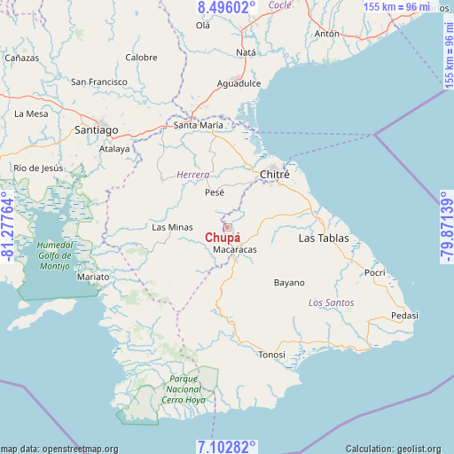
Chupá GPS coordinates[2]
7° 48' 0" North, 80° 34' 28.236" West
| Map corner | latitude | longitude |
|---|---|---|
| Upper-left | 8.49602°, | -81.27764° |
| Center: | 7.8°, | -80.57451° |
| Lower-right: | 7.10282°, | -79.87139° |
| Map W x H: | 154.9×154.9 km | = 96.3×96.3mi |
| max Lat: | 9.60898° ⇑89.7% North |
| Chupá: | 7.8° |
| min Lat: | ⇓10.3% South 7.26534° |
| min Long | Chupá | max Long |
| -82.91275° | -80.57451° | -77.38965° |
| W 50.4%⇐ | ⇒49.6% E |
Elevation
Elevation of Chupá is 90 m = 295 ft, and this is 82.1 m = 269 ft below average elevation for this country.
| Max E: |
2103 m = 6900 ft | 44.5% |
| Avg. | 172.1 m = 565 ft | |
| Chupá | 90 m = 295 ft | |
Min E: |
-1 m = -3 ft | 55.5% |
See also: Panama elevation on elevation.city.
Geographical zone
Chupá is located in North Torrid zone (between Equator and Tropic of Cancer). Distance of Equator is 867.3 km =538.9 mi to South.| Distance of | km | miles | from Chupá |
|---|---|---|---|
| North Pole | 9139.8 | 5679.2 | to North |
| Arctic Circle | 6533.9 | 4060 | to North |
| Tropic Cancer | 1738.6 | 1080.3 | to North |
| Equator | 867.3 | 538.9 | to South |


Nearby cities:
15 places around Chupá: (largest is in red/bold)
• Cedro Arriba
5.3 km =3.3 mi,  113°
113°
• El Calabacito
9.4 km =5.8 mi,  195°
195°
• El Capurí
11.2 km =7 mi,  222°
222°
• El Guásimo
5 km =3.1 mi,  81°
81°
• La Arena
5.9 km =3.7 mi, 200°
• La Colorada
3.4 km =2.1 mi,  38°
38°
• Las Cabras
8.9 km =5.5 mi,  18°
18°
• Las Guabas
8.2 km =5.1 mi, 78°
• Los Cerritos
4 km =2.5 mi,  265°
265°
• Los Pozos
8 km =5 mi,  256°
256°
• Macaracas
7.9 km =4.9 mi,  163°
163°
• Pesé
12.9 km =8 mi,  340°
340°
• Rincón Hondo
5.9 km =3.7 mi,  326°
326°
• Sabana Grande
11.3 km =7 mi,  321°
321°
• Villa Lourdes
11.6 km =7.2 mi, 83°
Sources, notices
• [Note1] Compared only with cities in Panama existing in our database
• [Src1] Map data: © OpenStreetMap contributors (CC-BY-SA)
• [Src2] Other city data from geonames.org with taken over terms of usage.
• [Src3] Geographical zone / Annual Mean Temperature by Robert A. Rohde @ Wikipedia
