El Cacao geodata
El Cacao (Panamá Oeste) is a seat of a third-order administrative division; located in Panama in America/Panama (GMT-5) time zone. With population of 636 people, there are 394 cities with bigger population in this country. Compared to other cities in Panama, 72.2% of cities are located further ↓South; 72.8% of cities are located further ←West and 75.4% of cities have lower elevation than El Cacao. Note1


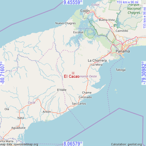
El Cacao GPS coordinates[2]
8° 45' 40.824" North, 80° 0' 46.584" West
| Map corner | latitude | longitude |
|---|---|---|
| Upper-left | 9.45559°, | -80.71607° |
| Center: | 8.76134°, | -80.01294° |
| Lower-right: | 8.06579°, | -79.30982° |
| Map W x H: | 154.5×154.5 km | = 96×96mi |
| max Lat: | 9.60898° ⇑27.8% North |
| El Cacao: | 8.76134° |
| min Lat: | ⇓72.2% South 7.26534° |
| min Long | El Cacao | max Long |
| -82.91275° | -80.01294° | -77.38965° |
| W 72.8%⇐ | ⇒27.2% E |
Elevation
Elevation of El Cacao is 204 m = 669 ft, and this is 31.9 m = 105 ft above average elevation for this country.
| Max E: |
2103 m = 6900 ft | 24.6% |
| El Cacao | 204 m 669 ft | |
| Avg. | 172.1 m = 565 ft | |
Min E: |
-1 m = -3 ft | 75.4% |
See also: Panama elevation on elevation.city.
Geographical zone
El Cacao is located in North Torrid zone (between Equator and Tropic of Cancer). Distance of Equator is 974.2 km =605.3 mi to South.| Distance of | km | miles | from El Cacao |
|---|---|---|---|
| North Pole | 9032.9 | 5612.8 | to North |
| Arctic Circle | 6427 | 3993.6 | to North |
| Tropic Cancer | 1631.7 | 1013.9 | to North |
| Equator | 974.2 | 605.3 | to South |


Nearby cities:
15 places around El Cacao: (largest is in red/bold)
• Buenos Aires
16.1 km =10 mi,  153°
153°
• Caimito
9.1 km =5.7 mi,  52°
52°
• Capira
14.6 km =9.1 mi,  92°
92°
• Cerro Campana
12.6 km =7.8 mi,  118°
118°
• Ciricito Abajo
8.3 km =5.2 mi,  300°
300°
• El Alto de Capira
14.1 km =8.8 mi,  103°
103°
• Las Ollas Abajo
14.3 km =8.9 mi, 51°
• Las Ollas Arriba
12.1 km =7.5 mi,  65°
65°
• Llano de Santa Rosa
16.5 km =10.3 mi, 90°
• Lídice
11.4 km =7.1 mi, 97°
• Nueva Arenosa
12.2 km =7.6 mi,  9°
9°
• Santa Rosa Número Uno
14.9 km =9.3 mi,  320°
320°
• Sorá
14.4 km =8.9 mi,  178°
178°
• Villa Carmen
16.3 km =10.1 mi,  75°
75°
• Villa Rosario
15.2 km =9.4 mi, 84°
Sources, notices
• [Note1] Compared only with cities in Panama existing in our database
• [Src1] Map data: © OpenStreetMap contributors (CC-BY-SA)
• [Src2] Other city data from geonames.org with taken over terms of usage.
• [Src3] Geographical zone / Annual Mean Temperature by Robert A. Rohde @ Wikipedia
