Buenos Aires geodata
Buenos Aires (Panamá Oeste) is a seat of a third-order administrative division; located in Panama in America/Panama (GMT-5) time zone. With population of 496 people, there are 491 cities with bigger population in this country. Compared to other cities in Panama, 66.1% of cities are located further ↓South; 74.1% of cities are located further ←West and 78.1% of cities have lower elevation than Buenos Aires. Note1


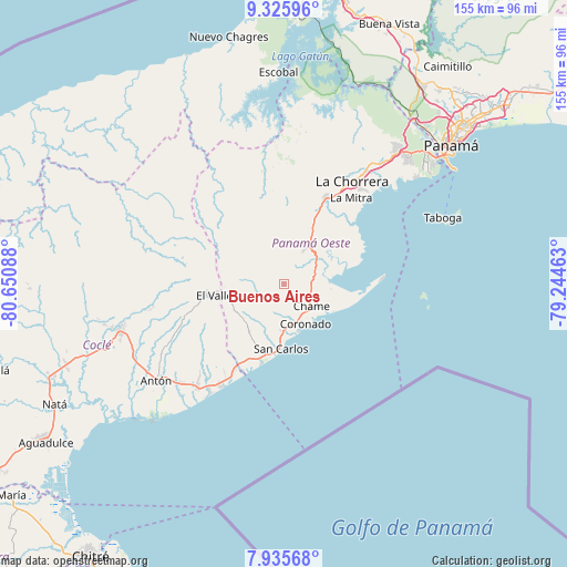
Buenos Aires GPS coordinates[2]
8° 37' 53.256" North, 79° 56' 51.9" West
| Map corner | latitude | longitude |
|---|---|---|
| Upper-left | 9.32596°, | -80.65088° |
| Center: | 8.63146°, | -79.94775° |
| Lower-right: | 7.93568°, | -79.24463° |
| Map W x H: | 154.6×154.6 km | = 96.1×96.1mi |
| max Lat: | 9.60898° ⇑33.9% North |
| Buenos Aires: | 8.63146° |
| min Lat: | ⇓66.1% South 7.26534° |
| min Long | Buenos Aires | max Long |
| -82.91275° | -79.94775° | -77.38965° |
| W 74.1%⇐ | ⇒25.9% E |
Elevation
Elevation of Buenos Aires is 232 m = 761 ft, and this is 59.9 m = 197 ft above average elevation for this country.
| Max E: |
2103 m = 6900 ft | 21.9% |
| Buenos Aires | 232 m 761 ft | |
| Avg. | 172.1 m = 565 ft | |
Min E: |
-1 m = -3 ft | 78.1% |
See also: Panama elevation on elevation.city.
Geographical zone
Buenos Aires is located in North Torrid zone (between Equator and Tropic of Cancer). Distance of Equator is 959.7 km =596.3 mi to South.| Distance of | km | miles | from Buenos Aires |
|---|---|---|---|
| North Pole | 9047.3 | 5621.7 | to North |
| Arctic Circle | 6441.4 | 4002.5 | to North |
| Tropic Cancer | 1646.2 | 1022.9 | to North |
| Equator | 959.7 | 596.3 | to South |


Nearby cities:
15 places around Buenos Aires: (largest is in red/bold)
• Bejuco
7.2 km =4.5 mi,  118°
118°
• Cabuya
6.7 km =4.2 mi,  160°
160°
• Cerro Campana
9.3 km =5.8 mi,  24°
24°
• Chame
9.1 km =5.7 mi,  131°
131°
• Coloncito
9.3 km =5.8 mi,  145°
145°
• El Espavé
8.6 km =5.3 mi,  67°
67°
• Guayabito
11.7 km =7.3 mi,  218°
218°
• La Cresta
7.2 km =4.5 mi,  82°
82°
• La Laguna
11.3 km =7 mi,  254°
254°
• Las Lajas
9.2 km =5.7 mi,  171°
171°
• Llano Grande
1.9 km =1.2 mi,  102°
102°
• Nueva Gorgona
12 km =7.5 mi,  138°
138°
• Sajalices
10.4 km =6.5 mi,  57°
57°
• San José
11.2 km =7 mi, 170°
• Sorá
6.7 km =4.2 mi,  270°
270°
Sources, notices
• [Note1] Compared only with cities in Panama existing in our database
• [Src1] Map data: © OpenStreetMap contributors (CC-BY-SA)
• [Src2] Other city data from geonames.org with taken over terms of usage.
• [Src3] Geographical zone / Annual Mean Temperature by Robert A. Rohde @ Wikipedia
