Cerro Campana geodata
Cerro Campana (Panamá) is a populated place; located in Panama in America/Panama (GMT-5) time zone. With population of 635 people, there are 395 cities with bigger population in this country. Compared to other cities in Panama, 70.3% of cities are located further ↓South; 75.2% of cities are located further ←West and 88.9% of cities have lower elevation than Cerro Campana. Note1


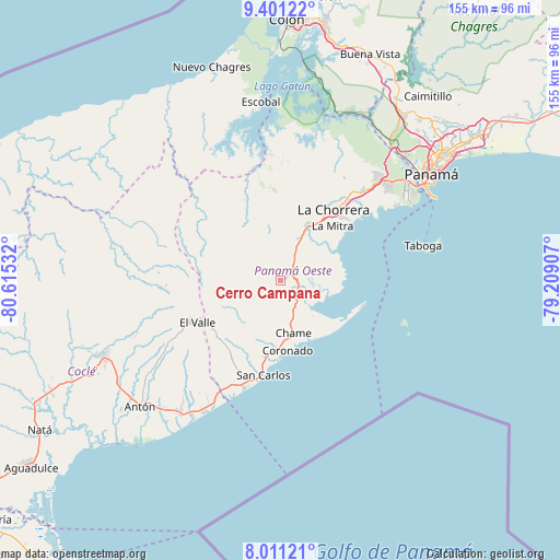
Cerro Campana GPS coordinates[2]
8° 42' 24.696" North, 79° 54' 43.884" West
| Map corner | latitude | longitude |
|---|---|---|
| Upper-left | 9.40122°, | -80.61532° |
| Center: | 8.70686°, | -79.91219° |
| Lower-right: | 8.01121°, | -79.20907° |
| Map W x H: | 154.6×154.6 km | = 96.1×96.1mi |
| max Lat: | 9.60898° ⇑29.7% North |
| Cerro Campana: | 8.70686° |
| min Lat: | ⇓70.3% South 7.26534° |
| min Long | Cerro Campana | max Long |
| -82.91275° | -79.91219° | -77.38965° |
| W 75.2%⇐ | ⇒24.8% E |
Elevation
Elevation of Cerro Campana is 427 m = 1401 ft, and this is 254.9 m = 836 ft above average elevation for this country.
| Max E: |
2103 m = 6900 ft | 11.1% |
| Cerro Campana | 427 m 1401 ft | |
| Avg. | 172.1 m = 565 ft | |
Min E: |
-1 m = -3 ft | 88.9% |
See also: Panama elevation on elevation.city.
Geographical zone
Cerro Campana is located in North Torrid zone (between Equator and Tropic of Cancer). Distance of Equator is 968.1 km =601.5 mi to South.| Distance of | km | miles | from Cerro Campana |
|---|---|---|---|
| North Pole | 9038.9 | 5616.5 | to North |
| Arctic Circle | 6433.1 | 3997.3 | to North |
| Tropic Cancer | 1637.8 | 1017.7 | to North |
| Equator | 968.1 | 601.5 | to South |


Nearby cities:
15 places around Cerro Campana: (largest is in red/bold)
• Bejuco
12.1 km =7.5 mi,  168°
168°
• Buenos Aires
9.3 km =5.8 mi,  204°
204°
• Caimito
12.3 km =7.6 mi,  341°
341°
• Capira
6.5 km =4 mi,  32°
32°
• Cermeño
7.5 km =4.7 mi,  59°
59°
• El Alto de Capira
3.9 km =2.4 mi,  43°
43°
• El Espavé
6.4 km =4 mi,  141°
141°
• La Cresta
8.2 km =5.1 mi,  156°
156°
• Las Ollas Arriba
11.1 km =6.9 mi,  359°
359°
• Llano Grande
9 km =5.6 mi,  193°
193°
• Llano de Santa Rosa
8.1 km =5 mi, 42°
• Lídice
4.7 km =2.9 mi,  3°
3°
• Sajalices
5.6 km =3.5 mi,  119°
119°
• Villa Carmen
11.2 km =7 mi,  24°
24°
• Villa Rosario
8.5 km =5.3 mi, 28°
Sources, notices
• [Note1] Compared only with cities in Panama existing in our database
• [Src1] Map data: © OpenStreetMap contributors (CC-BY-SA)
• [Src2] Other city data from geonames.org with taken over terms of usage.
• [Src3] Geographical zone / Annual Mean Temperature by Robert A. Rohde @ Wikipedia
